You are here: Home > Network List > IU - Global Seismograph Network (GSN - IRIS/USGS) Stations List
> Station PAB San Pablo, Spain > Earthquake Result Viewer
PAB San Pablo, Spain - Earthquake Result Viewer
| Earthquake location: |
Michoacan, Mexico |
| Earthquake latitude/longitude: |
18.2/-102.7 |
| Earthquake time(UTC): |
2012/04/11 (102) 22:55:10 GMT |
| Earthquake Depth: |
20 km |
| Earthquake Magnitude: |
5.8 MB, 6.7 MS, 6.5 MW, 6.7 MW |
| Earthquake Catalog/Contributor: |
WHDF/NEIC |
|
| Network: |
IU Global Seismograph Network (GSN - IRIS/USGS) |
| Station: |
PAB San Pablo, Spain |
| Lat/Lon: |
39.54 N/4.35 W |
| Elevation: |
950 m |
|
| Distance: |
84.8 deg |
| Az: |
50.193 deg |
| Baz: |
289.219 deg |
| Ray Param: |
0.045203272 |
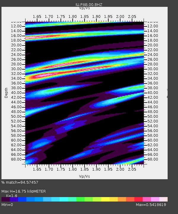
| Estimated Moho Depth: |
16.75 km |
| Estimated Crust Vp/Vs: |
1.60 |
| Assumed Crust Vp: |
6.276 km/s |
| Estimated Crust Vs: |
3.922 km/s |
| Estimated Crust Poisson's Ratio: |
0.18 |
|
| Radial Match: |
94.57457 % |
| Radial Bump: |
352 |
| Transverse Match: |
79.6666 % |
| Transverse Bump: |
400 |
| SOD ConfigId: |
558545 |
| Insert Time: |
2013-09-19 15:38:41.317 +0000 |
| GWidth: |
2.5 |
| Max Bumps: |
400 |
| Tol: |
0.001 |
|

Signal To Noise
| Channel | StoN | STA | LTA |
| IU:PAB:00:BHZ:20120411T23:07:11.718994Z | 16.490358 | 3.5662713E-6 | 2.1626401E-7 |
| IU:PAB:00:BH1:20120411T23:07:11.718994Z | 3.1170943 | 4.582478E-7 | 1.470112E-7 |
| IU:PAB:00:BH2:20120411T23:07:11.718994Z | 3.9413261 | 1.1934656E-6 | 3.028081E-7 |
| Arrivals |
| Ps | 1.6 SECOND |
| PpPs | 6.8 SECOND |
| PsPs/PpSs | 8.4 SECOND |


