You are here: Home > Network List > CU - Caribbean Network (USGS) Stations List
> Station GTBY Guantanamo Bay, Cuba > Earthquake Result Viewer
GTBY Guantanamo Bay, Cuba - Earthquake Result Viewer
| Earthquake location: |
Baja California, Mexico |
| Earthquake latitude/longitude: |
28.7/-113.1 |
| Earthquake time(UTC): |
2012/04/12 (103) 07:15:48 GMT |
| Earthquake Depth: |
13 km |
| Earthquake Magnitude: |
6.2 MB, 6.9 MS, 7.0 MW, 6.9 MW |
| Earthquake Catalog/Contributor: |
WHDF/NEIC |
|
| Network: |
CU Caribbean Network (USGS) |
| Station: |
GTBY Guantanamo Bay, Cuba |
| Lat/Lon: |
19.93 N/75.11 W |
| Elevation: |
79 m |
|
| Distance: |
35.6 deg |
| Az: |
95.576 deg |
| Baz: |
291.668 deg |
| Ray Param: |
0.077136755 |
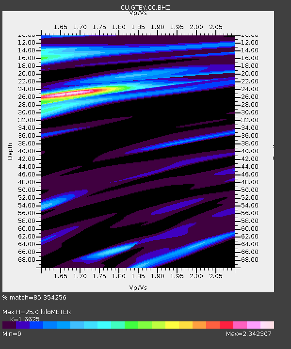
| Estimated Moho Depth: |
25.0 km |
| Estimated Crust Vp/Vs: |
1.66 |
| Assumed Crust Vp: |
6.048 km/s |
| Estimated Crust Vs: |
3.638 km/s |
| Estimated Crust Poisson's Ratio: |
0.22 |
|
| Radial Match: |
85.354256 % |
| Radial Bump: |
294 |
| Transverse Match: |
66.96763 % |
| Transverse Bump: |
400 |
| SOD ConfigId: |
558545 |
| Insert Time: |
2013-09-19 15:44:04.011 +0000 |
| GWidth: |
2.5 |
| Max Bumps: |
400 |
| Tol: |
0.001 |
|

Signal To Noise
| Channel | StoN | STA | LTA |
| CU:GTBY:00:BHZ:20120412T07:22:14.774994Z | 1.9535259 | 1.0056042E-6 | 5.1476366E-7 |
| CU:GTBY:00:BH1:20120412T07:22:14.774994Z | 0.88113683 | 6.2538754E-7 | 7.097508E-7 |
| CU:GTBY:00:BH2:20120412T07:22:14.774994Z | 1.3052639 | 8.610808E-7 | 6.596986E-7 |
| Arrivals |
| Ps | 2.9 SECOND |
| PpPs | 10 SECOND |
| PsPs/PpSs | 13 SECOND |


