You are here: Home > Network List > IU - Global Seismograph Network (GSN - IRIS/USGS) Stations List
> Station OTAV Otavalo, Ecuador > Earthquake Result Viewer
OTAV Otavalo, Ecuador - Earthquake Result Viewer
| Earthquake location: |
Baja California, Mexico |
| Earthquake latitude/longitude: |
28.7/-113.1 |
| Earthquake time(UTC): |
2012/04/12 (103) 07:15:48 GMT |
| Earthquake Depth: |
13 km |
| Earthquake Magnitude: |
6.2 MB, 6.9 MS, 7.0 MW, 6.9 MW |
| Earthquake Catalog/Contributor: |
WHDF/NEIC |
|
| Network: |
IU Global Seismograph Network (GSN - IRIS/USGS) |
| Station: |
OTAV Otavalo, Ecuador |
| Lat/Lon: |
0.24 N/78.45 W |
| Elevation: |
3510 m |
|
| Distance: |
43.6 deg |
| Az: |
124.4 deg |
| Baz: |
313.54 deg |
| Ray Param: |
0.0724656 |
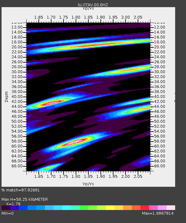
| Estimated Moho Depth: |
58.25 km |
| Estimated Crust Vp/Vs: |
1.79 |
| Assumed Crust Vp: |
6.472 km/s |
| Estimated Crust Vs: |
3.616 km/s |
| Estimated Crust Poisson's Ratio: |
0.27 |
|
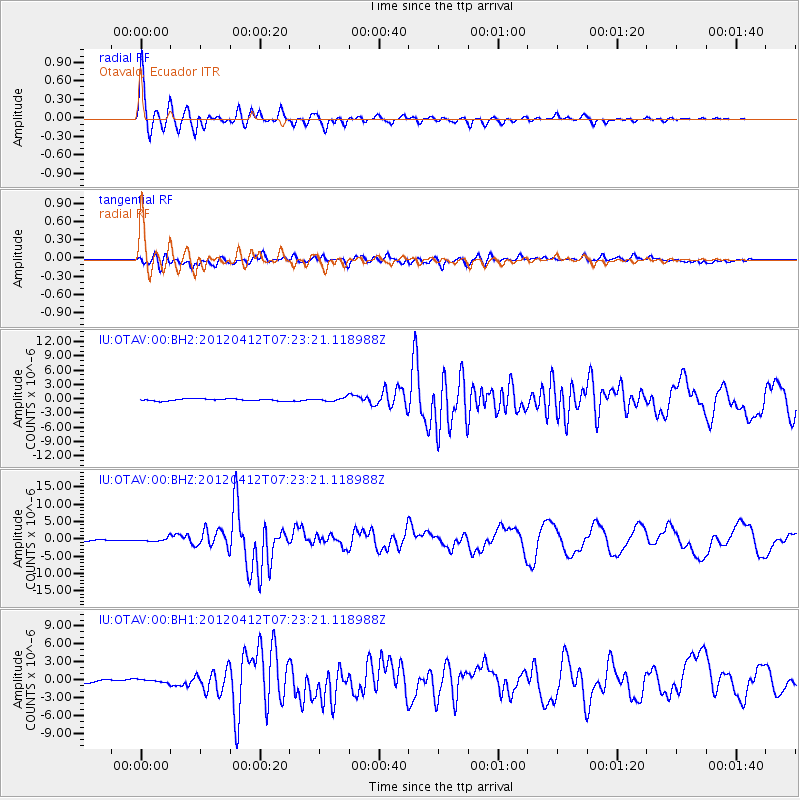
| Radial Match: |
97.92691 % |
| Radial Bump: |
319 |
| Transverse Match: |
75.87846 % |
| Transverse Bump: |
400 |
| SOD ConfigId: |
558545 |
| Insert Time: |
2013-09-19 15:44:42.686 +0000 |
| GWidth: |
2.5 |
| Max Bumps: |
400 |
| Tol: |
0.001 |
|
Signal To Noise
| Channel | StoN | STA | LTA |
| IU:OTAV:00:BHZ:20120412T07:23:21.118988Z | 2.54173 | 5.249444E-7 | 2.0653036E-7 |
| IU:OTAV:00:BH1:20120412T07:23:21.118988Z | 1.3994724 | 2.7040915E-7 | 1.9322222E-7 |
| IU:OTAV:00:BH2:20120412T07:23:21.118988Z | 1.708147 | 3.7301118E-7 | 2.1837181E-7 |
| Arrivals |
| Ps | 7.6 SECOND |
| PpPs | 23 SECOND |
| PsPs/PpSs | 31 SECOND |


