You are here: Home > Network List > CN - Canadian National Seismograph Network Stations List
> Station PMB Pemberton, British Columbia, Canada > Earthquake Result Viewer
PMB Pemberton, British Columbia, Canada - Earthquake Result Viewer
| Earthquake location: |
Eastern Sea Of Japan |
| Earthquake latitude/longitude: |
43.2/138.9 |
| Earthquake time(UTC): |
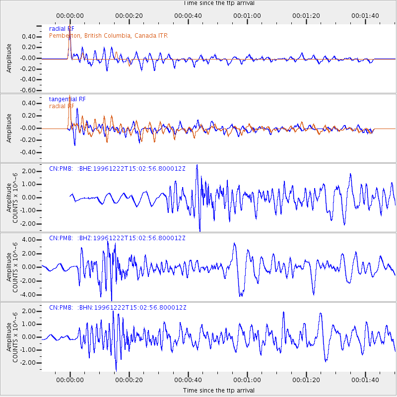
1996/12/22 (357) 14:53:27 GMT |
| Earthquake Depth: |
227 km |
| Earthquake Magnitude: |
6.0 MB, 6.5 UNKNOWN, 6.5 MW |
| Earthquake Catalog/Contributor: |
WHDF/NEIC |
|
| Network: |
CN Canadian National Seismograph Network |
| Station: |
PMB Pemberton, British Columbia, Canada |
| Lat/Lon: |
50.52 N/123.08 W |
| Elevation: |
400 m |
|
| Distance: |
62.6 deg |
| Az: |
45.397 deg |
| Baz: |
305.363 deg |
| Ray Param: |
0.059409894 |
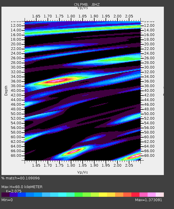
| Estimated Moho Depth: |
68.0 km |
| Estimated Crust Vp/Vs: |
2.08 |
| Assumed Crust Vp: |
6.566 km/s |
| Estimated Crust Vs: |
3.164 km/s |
| Estimated Crust Poisson's Ratio: |
0.35 |
|
| Radial Match: |
80.189896 % |
| Radial Bump: |
400 |
| Transverse Match: |
75.60715 % |
| Transverse Bump: |
400 |
| SOD ConfigId: |
4480 |
| Insert Time: |
2010-02-27 06:50:48.257 +0000 |
| GWidth: |
2.5 |
| Max Bumps: |
400 |
| Tol: |
0.001 |
|
Signal To Noise
| Channel | StoN | STA | LTA |
| CN:PMB: :BHZ:19961222T15:02:56.800012Z | 3.1690369 | 1.1414546E-6 | 3.6018977E-7 |
| CN:PMB: :BHN:19961222T15:02:56.800012Z | 1.4178991 | 3.3336474E-7 | 2.3511174E-7 |
| CN:PMB: :BHE:19961222T15:02:56.800012Z | 2.0585842 | 4.8340087E-7 | 2.3482198E-7 |
| Arrivals |
| Ps | 12 SECOND |
| PpPs | 31 SECOND |
| PsPs/PpSs | 42 SECOND |


