You are here: Home > Network List > US - United States National Seismic Network Stations List
> Station LONY Lake Ozonia, New York, USA > Earthquake Result Viewer
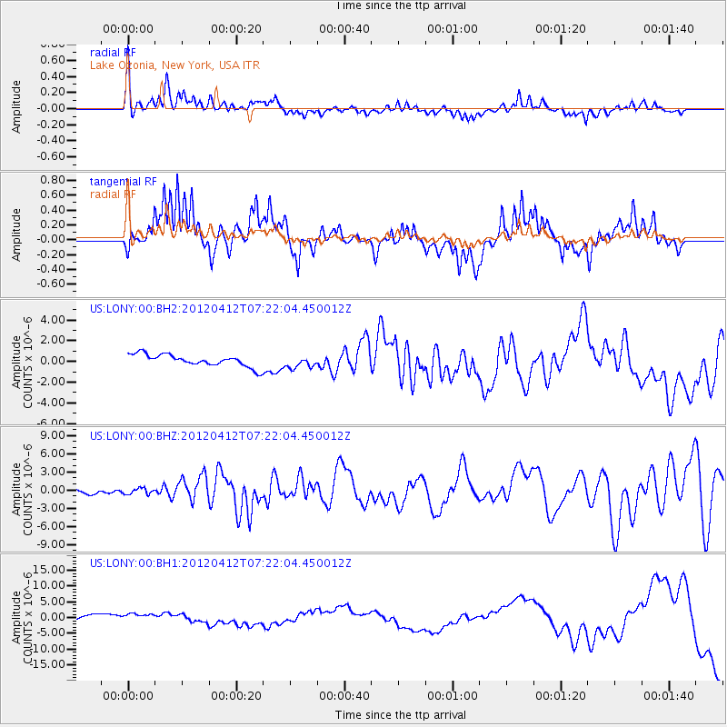
LONY Lake Ozonia, New York, USA - Earthquake Result Viewer
*The percent match for this event was below the threshold and hence no stack was calculated.
| Earthquake location: |
Baja California, Mexico |
| Earthquake latitude/longitude: |
28.7/-113.1 |
| Earthquake time(UTC): |
2012/04/12 (103) 07:15:48 GMT |
| Earthquake Depth: |
13 km |
| Earthquake Magnitude: |
6.2 MB, 6.9 MS, 7.0 MW, 6.9 MW |
| Earthquake Catalog/Contributor: |
WHDF/NEIC |
|
| Network: |
US United States National Seismic Network |
| Station: |
LONY Lake Ozonia, New York, USA |
| Lat/Lon: |
44.62 N/74.58 W |
| Elevation: |
440 m |
|
| Distance: |
34.4 deg |
| Az: |
51.953 deg |
| Baz: |
255.646 deg |
| Ray Param: |
$rayparam |
*The percent match for this event was below the threshold and hence was not used in the summary stack. |
|
| Radial Match: |
69.694 % |
| Radial Bump: |
400 |
| Transverse Match: |
60.47289 % |
| Transverse Bump: |
400 |
| SOD ConfigId: |
558545 |
| Insert Time: |
2013-09-19 15:45:21.326 +0000 |
| GWidth: |
2.5 |
| Max Bumps: |
400 |
| Tol: |
0.001 |
|
Signal To Noise
| Channel | StoN | STA | LTA |
| US:LONY:00:BHZ:20120412T07:22:04.450012Z | 1.3320065 | 4.7725104E-7 | 3.5829484E-7 |
| US:LONY:00:BH1:20120412T07:22:04.450012Z | 2.1465008 | 1.7402207E-6 | 8.1072443E-7 |
| US:LONY:00:BH2:20120412T07:22:04.450012Z | 1.0106945 | 5.8509613E-7 | 5.78905E-7 |
| Arrivals |
| Ps | |
| PpPs | |
| PsPs/PpSs | |


