You are here: Home > Network List > US - United States National Seismic Network Stations List
> Station COWI Conover, Wisconsin, USA > Earthquake Result Viewer
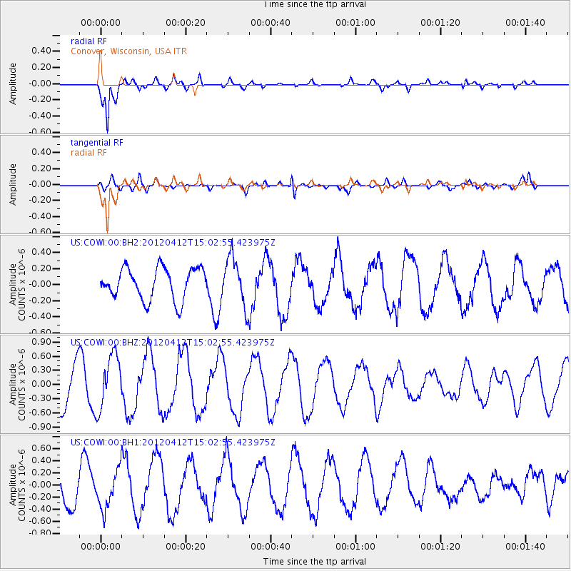
COWI Conover, Wisconsin, USA - Earthquake Result Viewer
*The percent match for this event was below the threshold and hence no stack was calculated.
| Earthquake location: |
Near East Coast Of Honshu, Japan |
| Earthquake latitude/longitude: |
37.5/141.5 |
| Earthquake time(UTC): |
2012/04/12 (103) 14:50:52 GMT |
| Earthquake Depth: |
25 km |
| Earthquake Magnitude: |
5.5 MW, 5.6 MB |
| Earthquake Catalog/Contributor: |
NEIC PDE/NEIC PDE-M |
|
| Network: |
US United States National Seismic Network |
| Station: |
COWI Conover, Wisconsin, USA |
| Lat/Lon: |
46.10 N/89.14 W |
| Elevation: |
523 m |
|
| Distance: |
85.2 deg |
| Az: |
32.659 deg |
| Baz: |
321.924 deg |
| Ray Param: |
$rayparam |
*The percent match for this event was below the threshold and hence was not used in the summary stack. |
|
| Radial Match: |
93.91188 % |
| Radial Bump: |
367 |
| Transverse Match: |
61.286983 % |
| Transverse Bump: |
400 |
| SOD ConfigId: |
558545 |
| Insert Time: |
2013-09-19 15:48:24.180 +0000 |
| GWidth: |
2.5 |
| Max Bumps: |
400 |
| Tol: |
0.001 |
|
Signal To Noise
| Channel | StoN | STA | LTA |
| US:COWI:00:BHZ:20120412T15:02:55.423975Z | 1.3230127 | 5.6632473E-7 | 4.280569E-7 |
| US:COWI:00:BH1:20120412T15:02:55.423975Z | 1.1626548 | 3.291492E-7 | 2.831014E-7 |
| US:COWI:00:BH2:20120412T15:02:55.423975Z | 1.5826259 | 3.0955536E-7 | 1.9559604E-7 |
| Arrivals |
| Ps | |
| PpPs | |
| PsPs/PpSs | |


