You are here: Home > Network List > CN - Canadian National Seismograph Network Stations List
> Station PMB Pemberton, British Columbia, Canada > Earthquake Result Viewer
PMB Pemberton, British Columbia, Canada - Earthquake Result Viewer
| Earthquake location: |
Off East Coast Of Kamchatka |
| Earthquake latitude/longitude: |
51.6/159.1 |
| Earthquake time(UTC): |
1996/06/21 (173) 13:57:10 GMT |
| Earthquake Depth: |
20 km |
| Earthquake Magnitude: |
6.0 MB, 6.6 MS, 7.0 UNKNOWN, 6.5 MS |
| Earthquake Catalog/Contributor: |
WHDF/NEIC |
|
| Network: |
CN Canadian National Seismograph Network |
| Station: |
PMB Pemberton, British Columbia, Canada |
| Lat/Lon: |
50.52 N/123.08 W |
| Elevation: |
400 m |
|
| Distance: |
46.7 deg |
| Az: |
58.99 deg |
| Baz: |
303.072 deg |
| Ray Param: |
0.070441276 |
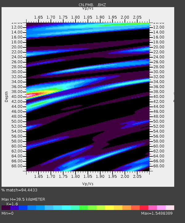
| Estimated Moho Depth: |
39.5 km |
| Estimated Crust Vp/Vs: |
1.60 |
| Assumed Crust Vp: |
6.566 km/s |
| Estimated Crust Vs: |
4.104 km/s |
| Estimated Crust Poisson's Ratio: |
0.18 |
|
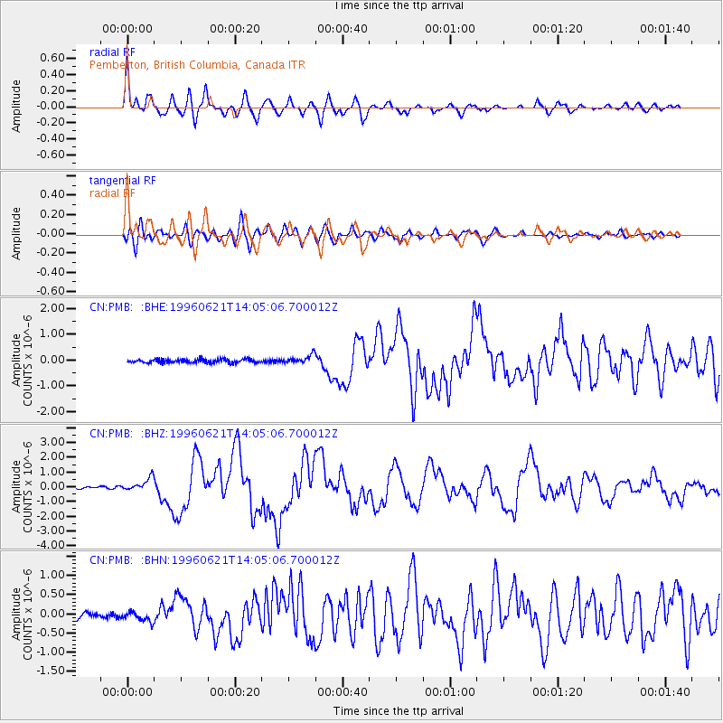
| Radial Match: |
94.4433 % |
| Radial Bump: |
400 |
| Transverse Match: |
87.18385 % |
| Transverse Bump: |
400 |
| SOD ConfigId: |
4480 |
| Insert Time: |
2010-02-27 06:51:25.975 +0000 |
| GWidth: |
2.5 |
| Max Bumps: |
400 |
| Tol: |
0.001 |
|
Signal To Noise
| Channel | StoN | STA | LTA |
| CN:PMB: :BHZ:19960621T14:05:06.700012Z | 6.975134 | 4.3542468E-7 | 6.242528E-8 |
| CN:PMB: :BHN:19960621T14:05:06.700012Z | 1.5719348 | 1.2863944E-7 | 8.18351E-8 |
| CN:PMB: :BHE:19960621T14:05:06.700012Z | 2.3416164 | 1.6738719E-7 | 7.1483605E-8 |
| Arrivals |
| Ps | 3.9 SECOND |
| PpPs | 15 SECOND |
| PsPs/PpSs | 18 SECOND |


