You are here: Home > Network List > CN - Canadian National Seismograph Network Stations List
> Station PMB Pemberton, British Columbia, Canada > Earthquake Result Viewer
PMB Pemberton, British Columbia, Canada - Earthquake Result Viewer

| Earthquake location: |
Guerrero, Mexico |
| Earthquake latitude/longitude: |
18.7/-101.6 |
| Earthquake time(UTC): |
1997/05/22 (142) 07:50:53 GMT |
| Earthquake Depth: |
70 km |
| Earthquake Magnitude: |
5.9 MB, 6.0 MS, 6.6 UNKNOWN, 6.5 MW |
| Earthquake Catalog/Contributor: |
WHDF/NEIC |
|
| Network: |
CN Canadian National Seismograph Network |
| Station: |
PMB Pemberton, British Columbia, Canada |
| Lat/Lon: |
50.52 N/123.08 W |
| Elevation: |
400 m |
|
| Distance: |
36.1 deg |
| Az: |
336.62 deg |
| Baz: |
143.894 deg |
| Ray Param: |
0.07667355 |
| Estimated Moho Depth: |
20.75 km |
| Estimated Crust Vp/Vs: |
2.09 |
| Assumed Crust Vp: |
6.566 km/s |
| Estimated Crust Vs: |
3.138 km/s |
| Estimated Crust Poisson's Ratio: |
0.35 |
|
| Radial Match: |
85.495056 % |
| Radial Bump: |
400 |
| Transverse Match: |
73.42082 % |
| Transverse Bump: |
400 |
| SOD ConfigId: |
4480 |
| Insert Time: |
2010-02-27 06:51:29.507 +0000 |
| GWidth: |
2.5 |
| Max Bumps: |
400 |
| Tol: |
0.001 |
|
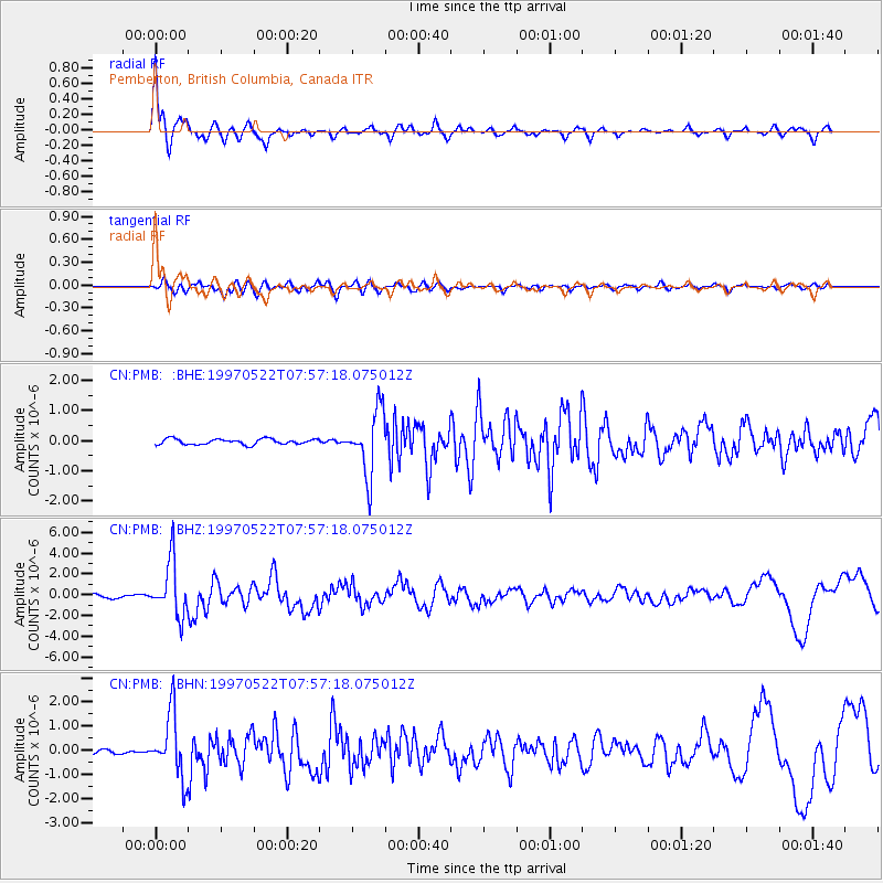
Signal To Noise
| Channel | StoN | STA | LTA |
| CN:PMB: :BHZ:19970522T07:57:18.075012Z | 16.13792 | 2.605193E-6 | 1.6143301E-7 |
| CN:PMB: :BHN:19970522T07:57:18.075012Z | 17.324753 | 1.3130353E-6 | 7.578956E-8 |
| CN:PMB: :BHE:19970522T07:57:18.075012Z | 11.586842 | 1.0562017E-6 | 9.1155265E-8 |
| Arrivals |
| Ps | 3.7 SECOND |
| PpPs | 9.1 SECOND |
| PsPs/PpSs | 13 SECOND |


