You are here: Home > Network List > CN - Canadian National Seismograph Network Stations List
> Station PMB Pemberton, British Columbia, Canada > Earthquake Result Viewer
PMB Pemberton, British Columbia, Canada - Earthquake Result Viewer
| Earthquake location: |
South Of Kermadec Islands |
| Earthquake latitude/longitude: |
-32.1/179.8 |
| Earthquake time(UTC): |
1997/05/25 (145) 23:22:33 GMT |
| Earthquake Depth: |
333 km |
| Earthquake Magnitude: |
6.2 MB, 7.1 UNKNOWN, 7.0 MW |
| Earthquake Catalog/Contributor: |
WHDF/NEIC |
|
| Network: |
CN Canadian National Seismograph Network |
| Station: |
PMB Pemberton, British Columbia, Canada |
| Lat/Lon: |
50.52 N/123.08 W |
| Elevation: |
400 m |
|
| Distance: |
96.5 deg |
| Az: |
32.66 deg |
| Baz: |
225.837 deg |
| Ray Param: |
0.040174574 |
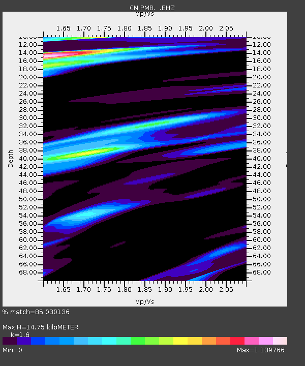
| Estimated Moho Depth: |
14.75 km |
| Estimated Crust Vp/Vs: |
1.60 |
| Assumed Crust Vp: |
6.566 km/s |
| Estimated Crust Vs: |
4.104 km/s |
| Estimated Crust Poisson's Ratio: |
0.18 |
|
| Radial Match: |
85.030136 % |
| Radial Bump: |
400 |
| Transverse Match: |
76.853 % |
| Transverse Bump: |
400 |
| SOD ConfigId: |
4480 |
| Insert Time: |
2010-02-27 06:51:31.610 +0000 |
| GWidth: |
2.5 |
| Max Bumps: |
400 |
| Tol: |
0.001 |
|
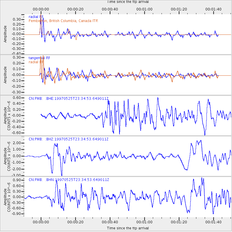
Signal To Noise
| Channel | StoN | STA | LTA |
| CN:PMB: :BHZ:19970525T23:34:53.649011Z | 3.083525 | 1.6728069E-7 | 5.4249824E-8 |
| CN:PMB: :BHN:19970525T23:34:53.649011Z | 1.2220544 | 4.154738E-8 | 3.399798E-8 |
| CN:PMB: :BHE:19970525T23:34:53.649011Z | 1.1634119 | 5.7830626E-8 | 4.9707786E-8 |
| Arrivals |
| Ps | 1.4 SECOND |
| PpPs | 5.7 SECOND |
| PsPs/PpSs | 7.1 SECOND |


