You are here: Home > Network List > IU - Global Seismograph Network (GSN - IRIS/USGS) Stations List
> Station HNR Honiara, Solomon Islands > Earthquake Result Viewer
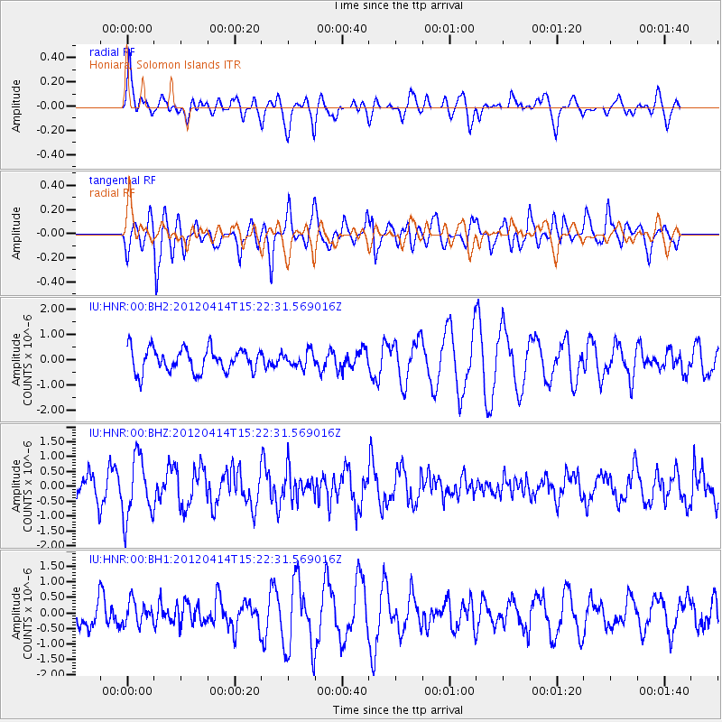
HNR Honiara, Solomon Islands - Earthquake Result Viewer
*The percent match for this event was below the threshold and hence no stack was calculated.
| Earthquake location: |
Kuril Islands |
| Earthquake latitude/longitude: |
49.4/155.7 |
| Earthquake time(UTC): |
2012/04/14 (105) 15:13:14 GMT |
| Earthquake Depth: |
90 km |
| Earthquake Magnitude: |
5.6 MW, 5.6 MW |
| Earthquake Catalog/Contributor: |
NEIC PDE/NEIC PDE-M |
|
| Network: |
IU Global Seismograph Network (GSN - IRIS/USGS) |
| Station: |
HNR Honiara, Solomon Islands |
| Lat/Lon: |
9.44 S/159.95 E |
| Elevation: |
100 m |
|
| Distance: |
58.7 deg |
| Az: |
175.037 deg |
| Baz: |
356.715 deg |
| Ray Param: |
$rayparam |
*The percent match for this event was below the threshold and hence was not used in the summary stack. |
|
| Radial Match: |
53.9236 % |
| Radial Bump: |
400 |
| Transverse Match: |
55.194393 % |
| Transverse Bump: |
400 |
| SOD ConfigId: |
558545 |
| Insert Time: |
2013-09-19 15:59:32.512 +0000 |
| GWidth: |
2.5 |
| Max Bumps: |
400 |
| Tol: |
0.001 |
|
Signal To Noise
| Channel | StoN | STA | LTA |
| IU:HNR:00:BHZ:20120414T15:22:31.569016Z | 3.0212173 | 1.0279632E-6 | 3.40248E-7 |
| IU:HNR:00:BH1:20120414T15:22:31.569016Z | 0.568706 | 3.680045E-7 | 6.47091E-7 |
| IU:HNR:00:BH2:20120414T15:22:31.569016Z | 0.64636934 | 2.993908E-7 | 4.631884E-7 |
| Arrivals |
| Ps | |
| PpPs | |
| PsPs/PpSs | |


