You are here: Home > Network List > IU - Global Seismograph Network (GSN - IRIS/USGS) Stations List
> Station MAKZ Makanchi, Kazakhstan > Earthquake Result Viewer
MAKZ Makanchi, Kazakhstan - Earthquake Result Viewer
*The percent match for this event was below the threshold and hence no stack was calculated.
| Earthquake location: |
Kuril Islands |
| Earthquake latitude/longitude: |
49.4/155.7 |
| Earthquake time(UTC): |
2012/04/14 (105) 15:13:14 GMT |
| Earthquake Depth: |
90 km |
| Earthquake Magnitude: |
5.6 MW, 5.6 MW |
| Earthquake Catalog/Contributor: |
NEIC PDE/NEIC PDE-M |
|
| Network: |
IU Global Seismograph Network (GSN - IRIS/USGS) |
| Station: |
MAKZ Makanchi, Kazakhstan |
| Lat/Lon: |
46.81 N/81.98 E |
| Elevation: |
600 m |
|
| Distance: |
47.4 deg |
| Az: |
296.513 deg |
| Baz: |
58.366 deg |
| Ray Param: |
$rayparam |
*The percent match for this event was below the threshold and hence was not used in the summary stack. |
|
| Radial Match: |
76.08142 % |
| Radial Bump: |
348 |
| Transverse Match: |
45.15705 % |
| Transverse Bump: |
400 |
| SOD ConfigId: |
558545 |
| Insert Time: |
2013-09-19 15:59:42.867 +0000 |
| GWidth: |
2.5 |
| Max Bumps: |
400 |
| Tol: |
0.001 |
|
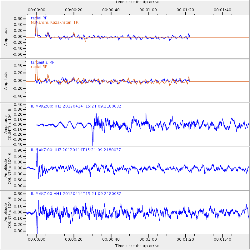
Signal To Noise
| Channel | StoN | STA | LTA |
| IU:MAKZ:00:HHZ:20120414T15:21:09.218003Z | 5.9085264 | 3.1251744E-7 | 5.289262E-8 |
| IU:MAKZ:00:HH1:20120414T15:21:09.218003Z | 4.2701397 | 9.9683994E-8 | 2.3344434E-8 |
| IU:MAKZ:00:HH2:20120414T15:21:09.218003Z | 3.951152 | 1.2733962E-7 | 3.2228478E-8 |
| Arrivals |
| Ps | |
| PpPs | |
| PsPs/PpSs | |


