You are here: Home > Network List > US - United States National Seismic Network Stations List
> Station DGMT Dagmar, Montana, USA > Earthquake Result Viewer
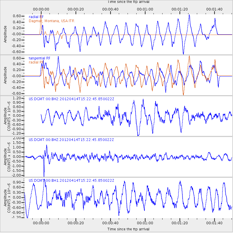
DGMT Dagmar, Montana, USA - Earthquake Result Viewer
*The percent match for this event was below the threshold and hence no stack was calculated.
| Earthquake location: |
Kuril Islands |
| Earthquake latitude/longitude: |
49.4/155.7 |
| Earthquake time(UTC): |
2012/04/14 (105) 15:13:14 GMT |
| Earthquake Depth: |
90 km |
| Earthquake Magnitude: |
5.6 MW, 5.6 MW |
| Earthquake Catalog/Contributor: |
NEIC PDE/NEIC PDE-M |
|
| Network: |
US United States National Seismic Network |
| Station: |
DGMT Dagmar, Montana, USA |
| Lat/Lon: |
48.47 N/104.20 W |
| Elevation: |
0.0 m |
|
| Distance: |
60.8 deg |
| Az: |
48.645 deg |
| Baz: |
312.51 deg |
| Ray Param: |
$rayparam |
*The percent match for this event was below the threshold and hence was not used in the summary stack. |
|
| Radial Match: |
57.407814 % |
| Radial Bump: |
400 |
| Transverse Match: |
49.42812 % |
| Transverse Bump: |
400 |
| SOD ConfigId: |
558545 |
| Insert Time: |
2013-09-19 16:00:42.089 +0000 |
| GWidth: |
2.5 |
| Max Bumps: |
400 |
| Tol: |
0.001 |
|
Signal To Noise
| Channel | StoN | STA | LTA |
| US:DGMT:00:BHZ:20120414T15:22:45.850022Z | 5.288911 | 6.347386E-7 | 1.2001311E-7 |
| US:DGMT:00:BH1:20120414T15:22:45.850022Z | 1.0897483 | 5.856928E-7 | 5.3745697E-7 |
| US:DGMT:00:BH2:20120414T15:22:45.850022Z | 0.6870161 | 2.0328656E-7 | 2.958978E-7 |
| Arrivals |
| Ps | |
| PpPs | |
| PsPs/PpSs | |


