You are here: Home > Network List > CN - Canadian National Seismograph Network Stations List
> Station PMB Pemberton, British Columbia, Canada > Earthquake Result Viewer
PMB Pemberton, British Columbia, Canada - Earthquake Result Viewer

| Earthquake location: |
Near Coast Of Venezuela |
| Earthquake latitude/longitude: |
10.6/-63.5 |
| Earthquake time(UTC): |
1997/07/09 (190) 19:24:13 GMT |
| Earthquake Depth: |
20 km |
| Earthquake Magnitude: |
6.2 MB, 6.8 MS, 7.0 UNKNOWN, 6.6 ME |
| Earthquake Catalog/Contributor: |
WHDF/NEIC |
|
| Network: |
CN Canadian National Seismograph Network |
| Station: |
PMB Pemberton, British Columbia, Canada |
| Lat/Lon: |
50.52 N/123.08 W |
| Elevation: |
400 m |
|
| Distance: |
62.7 deg |
| Az: |
321.725 deg |
| Baz: |
107.443 deg |
| Ray Param: |
0.060020104 |
| Estimated Moho Depth: |
34.0 km |
| Estimated Crust Vp/Vs: |
1.60 |
| Assumed Crust Vp: |
6.566 km/s |
| Estimated Crust Vs: |
4.104 km/s |
| Estimated Crust Poisson's Ratio: |
0.18 |
|
| Radial Match: |
90.03021 % |
| Radial Bump: |
347 |
| Transverse Match: |
79.50509 % |
| Transverse Bump: |
400 |
| SOD ConfigId: |
4480 |
| Insert Time: |
2010-02-27 06:51:45.031 +0000 |
| GWidth: |
2.5 |
| Max Bumps: |
400 |
| Tol: |
0.001 |
|
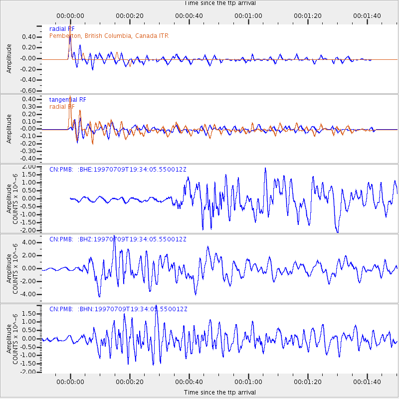
Signal To Noise
| Channel | StoN | STA | LTA |
| CN:PMB: :BHZ:19970709T19:34:05.550012Z | 2.237338 | 2.461017E-7 | 1.0999754E-7 |
| CN:PMB: :BHN:19970709T19:34:05.550012Z | 1.1673223 | 1.7623519E-7 | 1.5097389E-7 |
| CN:PMB: :BHE:19970709T19:34:05.550012Z | 1.2290629 | 1.324315E-7 | 1.07749976E-7 |
| Arrivals |
| Ps | 3.3 SECOND |
| PpPs | 13 SECOND |
| PsPs/PpSs | 16 SECOND |


