You are here: Home > Network List > US - United States National Seismic Network Stations List
> Station HLID Hailey, Idaho, USA > Earthquake Result Viewer
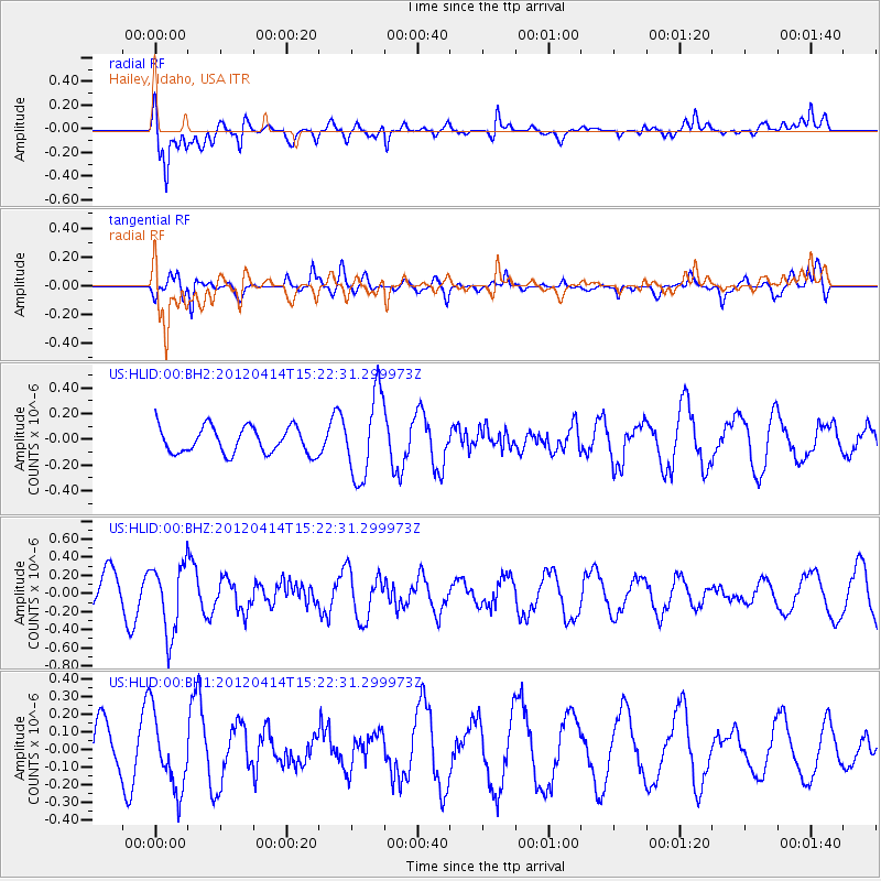
HLID Hailey, Idaho, USA - Earthquake Result Viewer
*The percent match for this event was below the threshold and hence no stack was calculated.
| Earthquake location: |
Kuril Islands |
| Earthquake latitude/longitude: |
49.4/155.7 |
| Earthquake time(UTC): |
2012/04/14 (105) 15:13:14 GMT |
| Earthquake Depth: |
90 km |
| Earthquake Magnitude: |
5.6 MW, 5.6 MW |
| Earthquake Catalog/Contributor: |
NEIC PDE/NEIC PDE-M |
|
| Network: |
US United States National Seismic Network |
| Station: |
HLID Hailey, Idaho, USA |
| Lat/Lon: |
43.56 N/114.41 W |
| Elevation: |
1772 m |
|
| Distance: |
58.6 deg |
| Az: |
58.344 deg |
| Baz: |
310.066 deg |
| Ray Param: |
$rayparam |
*The percent match for this event was below the threshold and hence was not used in the summary stack. |
|
| Radial Match: |
65.90876 % |
| Radial Bump: |
400 |
| Transverse Match: |
54.970577 % |
| Transverse Bump: |
375 |
| SOD ConfigId: |
558545 |
| Insert Time: |
2013-09-19 16:01:02.085 +0000 |
| GWidth: |
2.5 |
| Max Bumps: |
400 |
| Tol: |
0.001 |
|
Signal To Noise
| Channel | StoN | STA | LTA |
| US:HLID:00:BHZ:20120414T15:22:31.299973Z | 1.70112 | 3.8159575E-7 | 2.243203E-7 |
| US:HLID:00:BH1:20120414T15:22:31.299973Z | 1.7043973 | 2.1549468E-7 | 1.2643453E-7 |
| US:HLID:00:BH2:20120414T15:22:31.299973Z | 3.1733737 | 3.242082E-7 | 1.02165146E-7 |
| Arrivals |
| Ps | |
| PpPs | |
| PsPs/PpSs | |


