You are here: Home > Network List > US - United States National Seismic Network Stations List
> Station WMOK Wichita Mountains, Oklahoma, USA > Earthquake Result Viewer
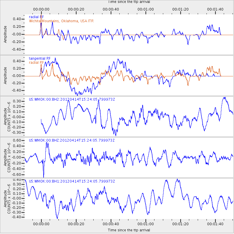
WMOK Wichita Mountains, Oklahoma, USA - Earthquake Result Viewer
*The percent match for this event was below the threshold and hence no stack was calculated.
| Earthquake location: |
Kuril Islands |
| Earthquake latitude/longitude: |
49.4/155.7 |
| Earthquake time(UTC): |
2012/04/14 (105) 15:13:14 GMT |
| Earthquake Depth: |
90 km |
| Earthquake Magnitude: |
5.6 MW, 5.6 MW |
| Earthquake Catalog/Contributor: |
NEIC PDE/NEIC PDE-M |
|
| Network: |
US United States National Seismic Network |
| Station: |
WMOK Wichita Mountains, Oklahoma, USA |
| Lat/Lon: |
34.74 N/98.78 W |
| Elevation: |
486 m |
|
| Distance: |
73.4 deg |
| Az: |
55.856 deg |
| Baz: |
318.944 deg |
| Ray Param: |
$rayparam |
*The percent match for this event was below the threshold and hence was not used in the summary stack. |
|
| Radial Match: |
42.76036 % |
| Radial Bump: |
400 |
| Transverse Match: |
41.29282 % |
| Transverse Bump: |
400 |
| SOD ConfigId: |
558545 |
| Insert Time: |
2013-09-19 16:02:06.052 +0000 |
| GWidth: |
2.5 |
| Max Bumps: |
400 |
| Tol: |
0.001 |
|
Signal To Noise
| Channel | StoN | STA | LTA |
| US:WMOK:00:BHZ:20120414T15:24:05.799973Z | 3.7692099 | 3.1685323E-7 | 8.4063565E-8 |
| US:WMOK:00:BH1:20120414T15:24:05.799973Z | 0.49935946 | 1.1385252E-7 | 2.2799712E-7 |
| US:WMOK:00:BH2:20120414T15:24:05.799973Z | 0.86158407 | 1.4636927E-7 | 1.6988392E-7 |
| Arrivals |
| Ps | |
| PpPs | |
| PsPs/PpSs | |


