You are here: Home > Network List > US - United States National Seismic Network Stations List
> Station WUAZ Wupatki, Arizona, USA > Earthquake Result Viewer
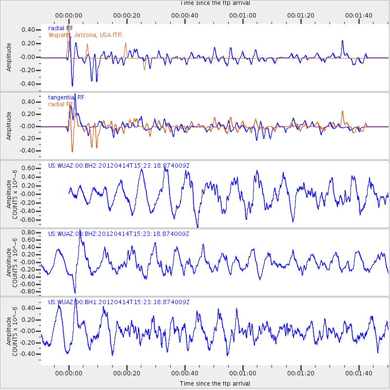
WUAZ Wupatki, Arizona, USA - Earthquake Result Viewer
*The percent match for this event was below the threshold and hence no stack was calculated.
| Earthquake location: |
Kuril Islands |
| Earthquake latitude/longitude: |
49.4/155.7 |
| Earthquake time(UTC): |
2012/04/14 (105) 15:13:14 GMT |
| Earthquake Depth: |
90 km |
| Earthquake Magnitude: |
5.6 MW, 5.6 MW |
| Earthquake Catalog/Contributor: |
NEIC PDE/NEIC PDE-M |
|
| Network: |
US United States National Seismic Network |
| Station: |
WUAZ Wupatki, Arizona, USA |
| Lat/Lon: |
35.52 N/111.37 W |
| Elevation: |
1592 m |
|
| Distance: |
65.8 deg |
| Az: |
63.284 deg |
| Baz: |
314.307 deg |
| Ray Param: |
$rayparam |
*The percent match for this event was below the threshold and hence was not used in the summary stack. |
|
| Radial Match: |
58.29908 % |
| Radial Bump: |
400 |
| Transverse Match: |
77.47479 % |
| Transverse Bump: |
400 |
| SOD ConfigId: |
558545 |
| Insert Time: |
2013-09-19 16:02:09.989 +0000 |
| GWidth: |
2.5 |
| Max Bumps: |
400 |
| Tol: |
0.001 |
|
Signal To Noise
| Channel | StoN | STA | LTA |
| US:WUAZ:00:BHZ:20120414T15:23:18.874009Z | 2.4827335 | 4.667296E-7 | 1.8799021E-7 |
| US:WUAZ:00:BH1:20120414T15:23:18.874009Z | 1.976608 | 2.9459287E-7 | 1.4903961E-7 |
| US:WUAZ:00:BH2:20120414T15:23:18.874009Z | 1.7814738 | 3.4196563E-7 | 1.919566E-7 |
| Arrivals |
| Ps | |
| PpPs | |
| PsPs/PpSs | |


