You are here: Home > Network List > IU - Global Seismograph Network (GSN - IRIS/USGS) Stations List
> Station MAJO Matsushiro, Japan > Earthquake Result Viewer
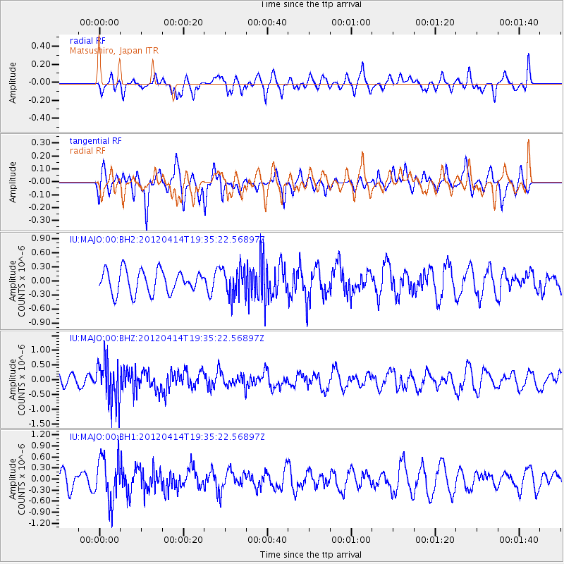
MAJO Matsushiro, Japan - Earthquake Result Viewer
*The percent match for this event was below the threshold and hence no stack was calculated.
| Earthquake location: |
Sunda Strait, Indonesia |
| Earthquake latitude/longitude: |
-6.8/105.5 |
| Earthquake time(UTC): |
2012/04/14 (105) 19:26:43 GMT |
| Earthquake Depth: |
63 km |
| Earthquake Magnitude: |
5.8 MW, 5.8 MW, 5.9 MB |
| Earthquake Catalog/Contributor: |
NEIC PDE/NEIC PDE-M |
|
| Network: |
IU Global Seismograph Network (GSN - IRIS/USGS) |
| Station: |
MAJO Matsushiro, Japan |
| Lat/Lon: |
36.55 N/138.20 E |
| Elevation: |
405 m |
|
| Distance: |
52.9 deg |
| Az: |
33.088 deg |
| Baz: |
222.314 deg |
| Ray Param: |
$rayparam |
*The percent match for this event was below the threshold and hence was not used in the summary stack. |
|
| Radial Match: |
39.25752 % |
| Radial Bump: |
400 |
| Transverse Match: |
69.970825 % |
| Transverse Bump: |
400 |
| SOD ConfigId: |
558545 |
| Insert Time: |
2013-09-19 16:03:12.701 +0000 |
| GWidth: |
2.5 |
| Max Bumps: |
400 |
| Tol: |
0.001 |
|
Signal To Noise
| Channel | StoN | STA | LTA |
| IU:MAJO:00:BHZ:20120414T19:35:22.56897Z | 2.538838 | 7.222429E-7 | 2.8447772E-7 |
| IU:MAJO:00:BH1:20120414T19:35:22.56897Z | 2.962845 | 6.121065E-7 | 2.0659417E-7 |
| IU:MAJO:00:BH2:20120414T19:35:22.56897Z | 1.2262493 | 2.967848E-7 | 2.4202646E-7 |
| Arrivals |
| Ps | |
| PpPs | |
| PsPs/PpSs | |


