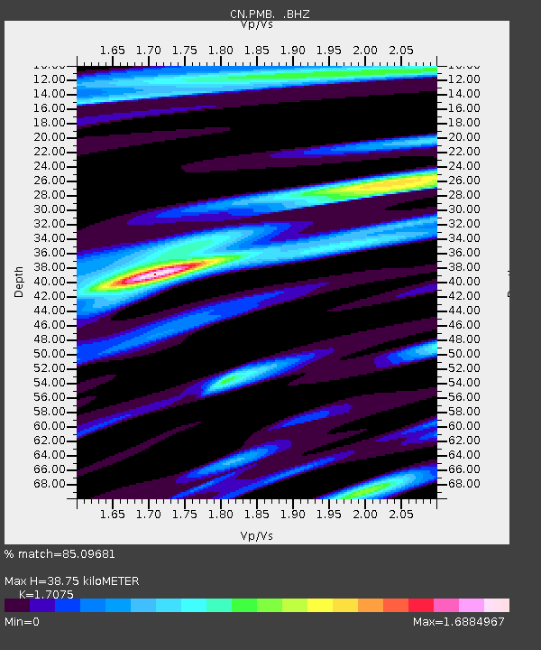
PMB Pemberton, British Columbia, Canada - Earthquake Result Viewer
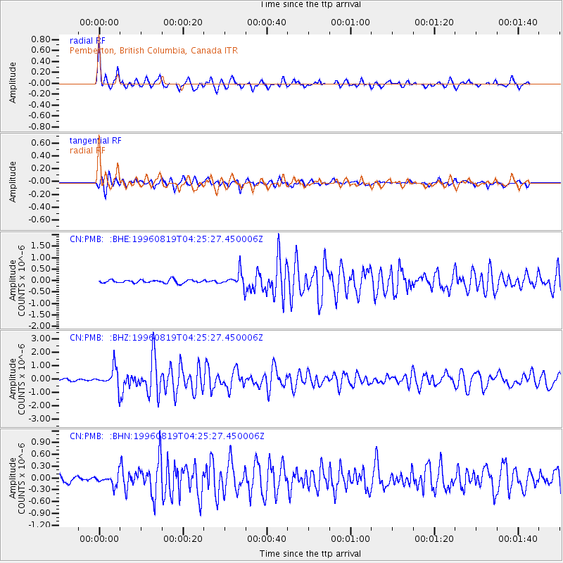
Earthquake location: Andreanof Islands, Aleutian Is.
Earthquake latitude/longitude: 51.5/-178.4
Earthquake time(UTC): 1996/08/19 (232) 04:19:16 GMT
Earthquake Depth: 33 km
Earthquake Magnitude: 5.7 MB, 5.6 MS, 6.0 UNKNOWN, 5.7 ML
Earthquake Catalog/Contributor: WHDF/NEIC
Network: CN Canadian National Seismograph Network
Station: PMB Pemberton, British Columbia, Canada
Lat/Lon: 50.52 N/123.08 W
Elevation: 400 m
Distance: 34.1 deg
Az: 69.317 deg
Baz: 293.502 deg
Ray Param: 0.07784077
Estimated Moho Depth: 38.75 km
Estimated Crust Vp/Vs: 1.71
Assumed Crust Vp: 6.566 km/s
Estimated Crust Vs: 3.845 km/s
Estimated Crust Poisson's Ratio: 0.24
Radial Match: 85.09681 %
Radial Bump: 400
Transverse Match: 80.58693 %
Transverse Bump: 400
SOD ConfigId: 4480
Insert Time: 2010-02-27 06:51:56.394 +0000
GWidth: 2.5
Max Bumps: 400
Tol: 0.001

Signal To Noise

ChannelStoNSTALTA
CN:PMB: :BHZ:19960819T04:25:27.450006Z11.5582717.561118E-76.5417375E-8
CN:PMB: :BHN:19960819T04:25:27.450006Z1.86359081.3809189E-77.40999E-8
CN:PMB: :BHE:19960819T04:25:27.450006Z4.9391623.4126515E-76.909374E-8
Arrivals
Ps4.5 SECOND
PpPs15 SECOND
PsPs/PpSs19 SECOND