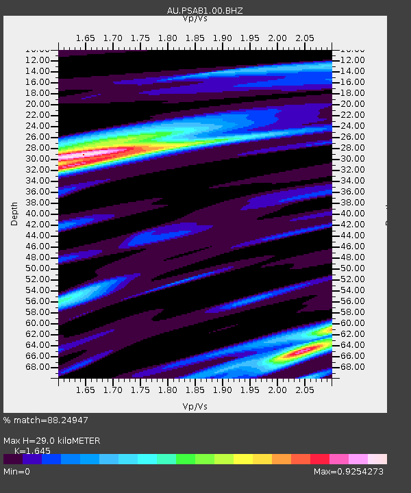
PSAB1 Pilbara Seismic Array Element B1 - Earthquake Result Viewer

Earthquake location: Vanuatu Islands
Earthquake latitude/longitude: -19.0/168.7
Earthquake time(UTC): 2012/04/14 (105) 22:05:26 GMT
Earthquake Depth: 11 km
Earthquake Magnitude: 6.3 MW, 6.0 MB, 6.2 MW, 6.2 MS
Earthquake Catalog/Contributor: NEIC PDE/NEIC PDE-M
Network: AU Australian Seismological Centre
Station: PSAB1 Pilbara Seismic Array Element B1
Lat/Lon: 21.57 S/119.82 E
Elevation: 317 m
Distance: 45.8 deg
Az: 258.072 deg
Baz: 95.884 deg
Ray Param: 0.07102656
Estimated Moho Depth: 29.0 km
Estimated Crust Vp/Vs: 1.64
Assumed Crust Vp: 6.464 km/s
Estimated Crust Vs: 3.929 km/s
Estimated Crust Poisson's Ratio: 0.21
Radial Match: 88.24947 %
Radial Bump: 391
Transverse Match: 60.565002 %
Transverse Bump: 400
SOD ConfigId: 558545
Insert Time: 2013-09-19 16:06:38.678 +0000
GWidth: 2.5
Max Bumps: 400
Tol: 0.001

Signal To Noise

ChannelStoNSTALTA
AU:PSAB1:00:BHZ:20120414T22:13:17.294014Z9.3974842.7973456E-62.9766963E-7
AU:PSAB1:00:BH1:20120414T22:13:17.294014Z10.458421.5554273E-61.4872488E-7
AU:PSAB1:00:BH2:20120414T22:13:17.294014Z2.05981763.7560613E-71.8234923E-7
Arrivals
Ps3.1 SECOND
PpPs11 SECOND
PsPs/PpSs14 SECOND