You are here: Home > Network List > CN - Canadian National Seismograph Network Stations List
> Station PMB Pemberton, British Columbia, Canada > Earthquake Result Viewer
PMB Pemberton, British Columbia, Canada - Earthquake Result Viewer
| Earthquake location: |
Fiji Islands Region |
| Earthquake latitude/longitude: |
-21.0/-179.2 |
| Earthquake time(UTC): |
1997/11/04 (308) 10:40:43 GMT |
| Earthquake Depth: |
621 km |
| Earthquake Magnitude: |
5.7 UNKNOWN, 5.1 MB |
| Earthquake Catalog/Contributor: |
WHDF/NEIC |
|
| Network: |
CN Canadian National Seismograph Network |
| Station: |
PMB Pemberton, British Columbia, Canada |
| Lat/Lon: |
50.52 N/123.08 W |
| Elevation: |
400 m |
|
| Distance: |
86.7 deg |
| Az: |
32.067 deg |
| Baz: |
230.982 deg |
| Ray Param: |
0.04205612 |
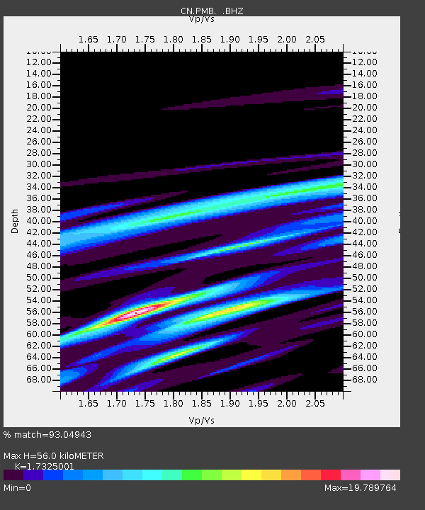
| Estimated Moho Depth: |
56.0 km |
| Estimated Crust Vp/Vs: |
1.73 |
| Assumed Crust Vp: |
6.566 km/s |
| Estimated Crust Vs: |
3.79 km/s |
| Estimated Crust Poisson's Ratio: |
0.25 |
|
| Radial Match: |
93.04943 % |
| Radial Bump: |
242 |
| Transverse Match: |
92.45628 % |
| Transverse Bump: |
288 |
| SOD ConfigId: |
4480 |
| Insert Time: |
2010-02-27 06:51:57.736 +0000 |
| GWidth: |
2.5 |
| Max Bumps: |
400 |
| Tol: |
0.001 |
|
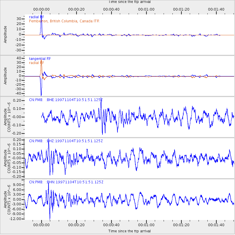
Signal To Noise
| Channel | StoN | STA | LTA |
| CN:PMB: :BHZ:19971104T10:51:51.125Z | 1.80425 | 7.002775E-8 | 3.881267E-8 |
| CN:PMB: :BHN:19971104T10:51:51.125Z | 2.041468 | 3.9361803E-6 | 1.9281129E-6 |
| CN:PMB: :BHE:19971104T10:51:51.125Z | 1.7816994 | 7.981128E-8 | 4.479503E-8 |
| Arrivals |
| Ps | 6.4 SECOND |
| PpPs | 23 SECOND |
| PsPs/PpSs | 29 SECOND |


