You are here: Home > Network List > IU - Global Seismograph Network (GSN - IRIS/USGS) Stations List
> Station MBWA Marble Bar, Western Australia > Earthquake Result Viewer
MBWA Marble Bar, Western Australia - Earthquake Result Viewer
| Earthquake location: |
Vanuatu Islands |
| Earthquake latitude/longitude: |
-19.0/168.7 |
| Earthquake time(UTC): |
2012/04/14 (105) 22:05:26 GMT |
| Earthquake Depth: |
11 km |
| Earthquake Magnitude: |
6.3 MW, 6.0 MB, 6.2 MW, 6.2 MS |
| Earthquake Catalog/Contributor: |
NEIC PDE/NEIC PDE-M |
|
| Network: |
IU Global Seismograph Network (GSN - IRIS/USGS) |
| Station: |
MBWA Marble Bar, Western Australia |
| Lat/Lon: |
21.16 S/119.73 E |
| Elevation: |
190 m |
|
| Distance: |
45.9 deg |
| Az: |
258.624 deg |
| Baz: |
96.301 deg |
| Ray Param: |
0.07094772 |
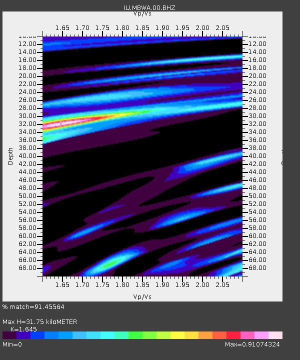
| Estimated Moho Depth: |
31.75 km |
| Estimated Crust Vp/Vs: |
1.64 |
| Assumed Crust Vp: |
6.464 km/s |
| Estimated Crust Vs: |
3.929 km/s |
| Estimated Crust Poisson's Ratio: |
0.21 |
|
| Radial Match: |
91.45564 % |
| Radial Bump: |
400 |
| Transverse Match: |
67.96805 % |
| Transverse Bump: |
400 |
| SOD ConfigId: |
558545 |
| Insert Time: |
2013-09-19 16:07:42.960 +0000 |
| GWidth: |
2.5 |
| Max Bumps: |
400 |
| Tol: |
0.001 |
|

Signal To Noise
| Channel | StoN | STA | LTA |
| IU:MBWA:00:BHZ:20120414T22:13:18.319008Z | 10.990303 | 3.0017932E-6 | 2.731311E-7 |
| IU:MBWA:00:BH1:20120414T22:13:18.319008Z | 9.089738 | 1.440307E-6 | 1.5845418E-7 |
| IU:MBWA:00:BH2:20120414T22:13:18.319008Z | 4.2509027 | 1.0505132E-6 | 2.4712708E-7 |
| Arrivals |
| Ps | 3.4 SECOND |
| PpPs | 12 SECOND |
| PsPs/PpSs | 16 SECOND |


