You are here: Home > Network List > CN - Canadian National Seismograph Network Stations List
> Station PMB Pemberton, British Columbia, Canada > Earthquake Result Viewer
PMB Pemberton, British Columbia, Canada - Earthquake Result Viewer
| Earthquake location: |
Taiwan Region |
| Earthquake latitude/longitude: |
21.9/121.5 |
| Earthquake time(UTC): |
1996/09/05 (249) 23:42:06 GMT |
| Earthquake Depth: |
20 km |
| Earthquake Magnitude: |
6.4 MB, 6.6 MS, 6.8 UNKNOWN, 6.8 ME |
| Earthquake Catalog/Contributor: |
WHDF/NEIC |
|
| Network: |
CN Canadian National Seismograph Network |
| Station: |
PMB Pemberton, British Columbia, Canada |
| Lat/Lon: |
50.52 N/123.08 W |
| Elevation: |
400 m |
|
| Distance: |
88.2 deg |
| Az: |
35.227 deg |
| Baz: |
302.948 deg |
| Ray Param: |
0.042723827 |
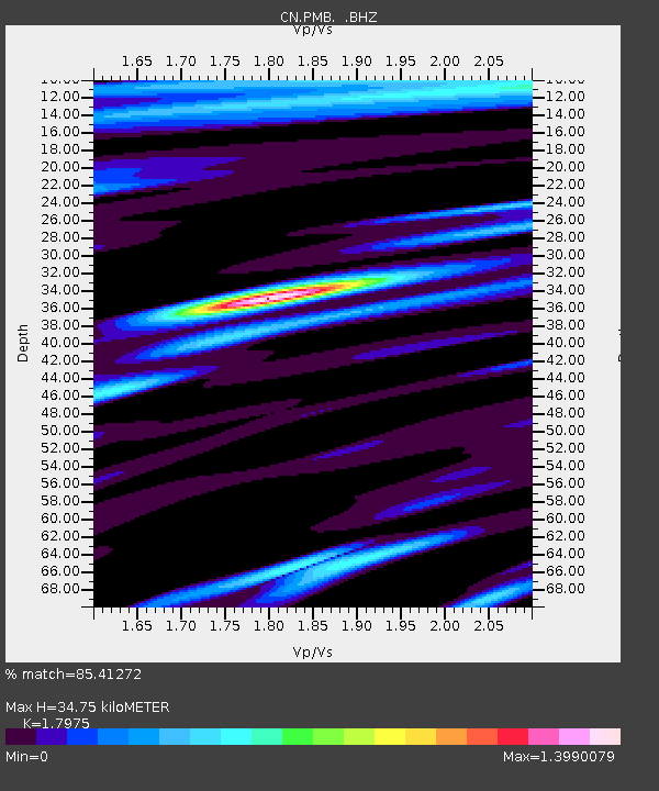
| Estimated Moho Depth: |
34.75 km |
| Estimated Crust Vp/Vs: |
1.80 |
| Assumed Crust Vp: |
6.566 km/s |
| Estimated Crust Vs: |
3.653 km/s |
| Estimated Crust Poisson's Ratio: |
0.28 |
|
| Radial Match: |
85.41272 % |
| Radial Bump: |
400 |
| Transverse Match: |
76.51587 % |
| Transverse Bump: |
400 |
| SOD ConfigId: |
4480 |
| Insert Time: |
2010-02-27 06:52:03.214 +0000 |
| GWidth: |
2.5 |
| Max Bumps: |
400 |
| Tol: |
0.001 |
|
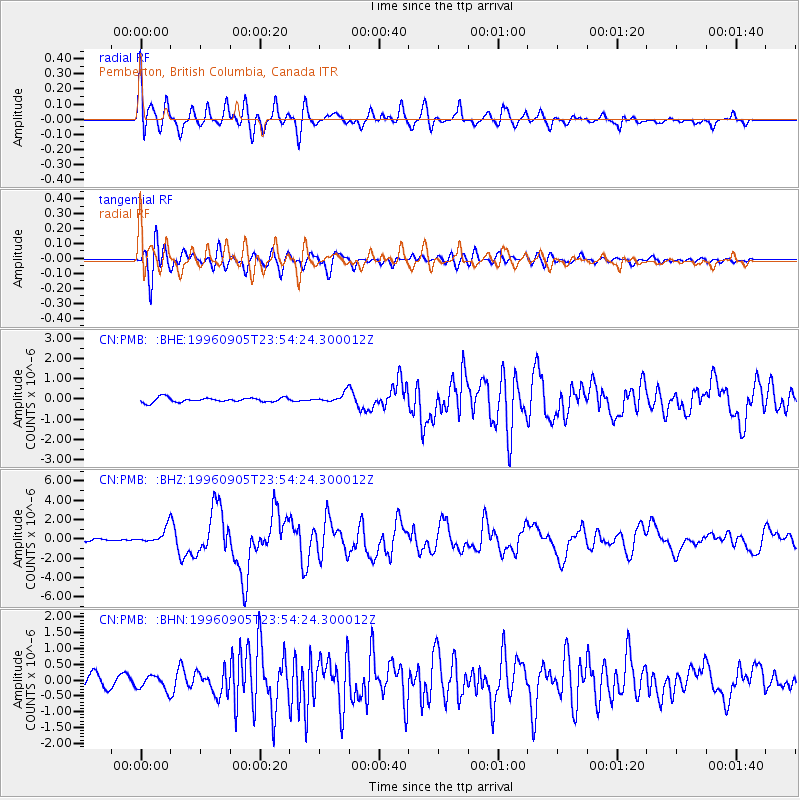
Signal To Noise
| Channel | StoN | STA | LTA |
| CN:PMB: :BHZ:19960905T23:54:24.300012Z | 7.3233905 | 8.018463E-7 | 1.0949113E-7 |
| CN:PMB: :BHN:19960905T23:54:24.300012Z | 1.4231578 | 2.2928297E-7 | 1.611086E-7 |
| CN:PMB: :BHE:19960905T23:54:24.300012Z | 2.0622437 | 2.2784837E-7 | 1.10485665E-7 |
| Arrivals |
| Ps | 4.3 SECOND |
| PpPs | 14 SECOND |
| PsPs/PpSs | 19 SECOND |


