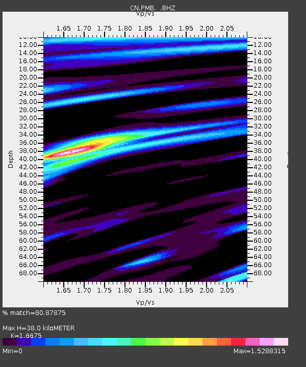
PMB Pemberton, British Columbia, Canada - Earthquake Result Viewer
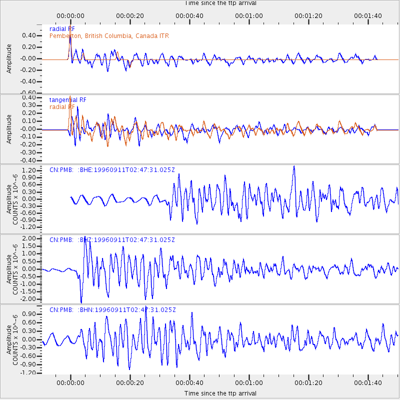
Earthquake location: Near East Coast Of Honshu, Japan
Earthquake latitude/longitude: 35.5/140.9
Earthquake time(UTC): 1996/09/11 (255) 02:37:14 GMT
Earthquake Depth: 55 km
Earthquake Magnitude: 6.1 MB, 5.7 MS, 6.2 UNKNOWN, 6.1 MW
Earthquake Catalog/Contributor: WHDF/NEIC
Network: CN Canadian National Seismograph Network
Station: PMB Pemberton, British Columbia, Canada
Lat/Lon: 50.52 N/123.08 W
Elevation: 400 m
Distance: 67.0 deg
Az: 43.619 deg
Baz: 298.193 deg
Ray Param: 0.057141278
Estimated Moho Depth: 38.0 km
Estimated Crust Vp/Vs: 1.67
Assumed Crust Vp: 6.566 km/s
Estimated Crust Vs: 3.938 km/s
Estimated Crust Poisson's Ratio: 0.22
Radial Match: 80.87875 %
Radial Bump: 400
Transverse Match: 76.30173 %
Transverse Bump: 400
SOD ConfigId: 4480
Insert Time: 2010-02-27 06:52:10.616 +0000
GWidth: 2.5
Max Bumps: 400
Tol: 0.001

Signal To Noise

ChannelStoNSTALTA
CN:PMB: :BHZ:19960911T02:47:31.025Z7.1699758.5807164E-71.1967568E-7
CN:PMB: :BHN:19960911T02:47:31.025Z1.02991511.667918E-71.6194714E-7
CN:PMB: :BHE:19960911T02:47:31.025Z2.64007143.0749624E-71.164727E-7
Arrivals
Ps4.0 SECOND
PpPs15 SECOND
PsPs/PpSs19 SECOND