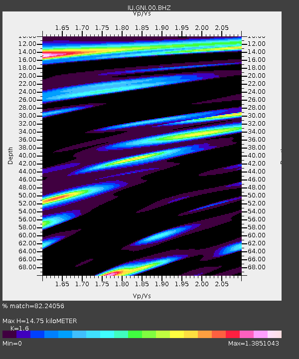
GNI Garni, Armenia - Earthquake Result Viewer
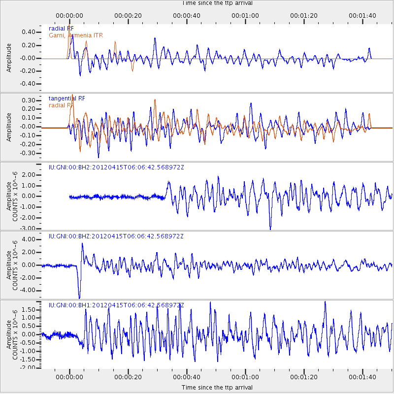
Earthquake location: Off W Coast Of Northern Sumatra
Earthquake latitude/longitude: 2.6/90.3
Earthquake time(UTC): 2012/04/15 (106) 05:57:40 GMT
Earthquake Depth: 25 km
Earthquake Magnitude: 6.2 MW, 6.1 MS, 6.1 MB, 6.2 MW
Earthquake Catalog/Contributor: NEIC PDE/NEIC PDE-M
Network: IU Global Seismograph Network (GSN - IRIS/USGS)
Station: GNI Garni, Armenia
Lat/Lon: 40.15 N/44.74 E
Elevation: 1609 m
Distance: 55.6 deg
Az: 318.469 deg
Baz: 120.217 deg
Ray Param: 0.06465973
Estimated Moho Depth: 14.75 km
Estimated Crust Vp/Vs: 1.60
Assumed Crust Vp: 6.291 km/s
Estimated Crust Vs: 3.932 km/s
Estimated Crust Poisson's Ratio: 0.18
Radial Match: 82.24056 %
Radial Bump: 400
Transverse Match: 83.42432 %
Transverse Bump: 400
SOD ConfigId: 558545
Insert Time: 2013-09-19 16:09:53.700 +0000
GWidth: 2.5
Max Bumps: 400
Tol: 0.001

Signal To Noise

ChannelStoNSTALTA
IU:GNI:00:BHZ:20120415T06:06:42.568972Z20.0585442.004667E-69.9940806E-8
IU:GNI:00:BH1:20120415T06:06:42.568972Z3.21394753.1516254E-79.806088E-8
IU:GNI:00:BH2:20120415T06:06:42.568972Z6.15780545.6843345E-79.231105E-8
Arrivals
Ps1.5 SECOND
PpPs5.8 SECOND
PsPs/PpSs7.3 SECOND