You are here: Home > Network List > IU - Global Seismograph Network (GSN - IRIS/USGS) Stations List
> Station HNR Honiara, Solomon Islands > Earthquake Result Viewer
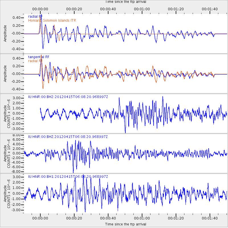
HNR Honiara, Solomon Islands - Earthquake Result Viewer
*The percent match for this event was below the threshold and hence no stack was calculated.
| Earthquake location: |
Off W Coast Of Northern Sumatra |
| Earthquake latitude/longitude: |
2.6/90.3 |
| Earthquake time(UTC): |
2012/04/15 (106) 05:57:40 GMT |
| Earthquake Depth: |
25 km |
| Earthquake Magnitude: |
6.2 MW, 6.1 MS, 6.1 MB, 6.2 MW |
| Earthquake Catalog/Contributor: |
NEIC PDE/NEIC PDE-M |
|
| Network: |
IU Global Seismograph Network (GSN - IRIS/USGS) |
| Station: |
HNR Honiara, Solomon Islands |
| Lat/Lon: |
9.44 S/159.95 E |
| Elevation: |
100 m |
|
| Distance: |
70.4 deg |
| Az: |
100.895 deg |
| Baz: |
276.133 deg |
| Ray Param: |
$rayparam |
*The percent match for this event was below the threshold and hence was not used in the summary stack. |
|
| Radial Match: |
81.55635 % |
| Radial Bump: |
400 |
| Transverse Match: |
68.366615 % |
| Transverse Bump: |
400 |
| SOD ConfigId: |
558545 |
| Insert Time: |
2013-09-19 16:10:00.758 +0000 |
| GWidth: |
2.5 |
| Max Bumps: |
400 |
| Tol: |
0.001 |
|
Signal To Noise
| Channel | StoN | STA | LTA |
| IU:HNR:00:BHZ:20120415T06:08:20.968997Z | 2.0440588 | 1.0957376E-6 | 5.3605976E-7 |
| IU:HNR:00:BH1:20120415T06:08:20.968997Z | 1.8834798 | 6.9380695E-7 | 3.6836443E-7 |
| IU:HNR:00:BH2:20120415T06:08:20.968997Z | 1.139596 | 6.230187E-7 | 5.467014E-7 |
| Arrivals |
| Ps | |
| PpPs | |
| PsPs/PpSs | |


