You are here: Home > Network List > US - United States National Seismic Network Stations List
> Station CBKS Cedar Bluff, Kansas, USA > Earthquake Result Viewer
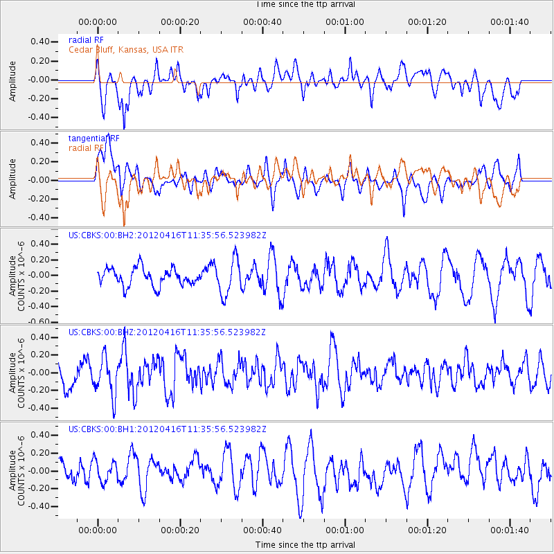
CBKS Cedar Bluff, Kansas, USA - Earthquake Result Viewer
*The percent match for this event was below the threshold and hence no stack was calculated.
| Earthquake location: |
Southern Greece |
| Earthquake latitude/longitude: |
36.6/21.5 |
| Earthquake time(UTC): |
2012/04/16 (107) 11:23:43 GMT |
| Earthquake Depth: |
29 km |
| Earthquake Magnitude: |
5.8 MW, 5.7 MW |
| Earthquake Catalog/Contributor: |
NEIC PDE/NEIC PDE-M |
|
| Network: |
US United States National Seismic Network |
| Station: |
CBKS Cedar Bluff, Kansas, USA |
| Lat/Lon: |
38.81 N/99.74 W |
| Elevation: |
677 m |
|
| Distance: |
87.4 deg |
| Az: |
318.023 deg |
| Baz: |
43.525 deg |
| Ray Param: |
$rayparam |
*The percent match for this event was below the threshold and hence was not used in the summary stack. |
|
| Radial Match: |
63.04397 % |
| Radial Bump: |
400 |
| Transverse Match: |
74.53186 % |
| Transverse Bump: |
400 |
| SOD ConfigId: |
558545 |
| Insert Time: |
2013-09-19 16:15:09.084 +0000 |
| GWidth: |
2.5 |
| Max Bumps: |
400 |
| Tol: |
0.001 |
|
Signal To Noise
| Channel | StoN | STA | LTA |
| US:CBKS:00:BHZ:20120416T11:35:56.523982Z | 1.3019613 | 2.1370289E-7 | 1.6413921E-7 |
| US:CBKS:00:BH1:20120416T11:35:56.523982Z | 1.0940758 | 1.3552585E-7 | 1.2387245E-7 |
| US:CBKS:00:BH2:20120416T11:35:56.523982Z | 2.13826 | 2.35368E-7 | 1.1007456E-7 |
| Arrivals |
| Ps | |
| PpPs | |
| PsPs/PpSs | |


