You are here: Home > Network List > CN - Canadian National Seismograph Network Stations List
> Station PMB Pemberton, British Columbia, Canada > Earthquake Result Viewer
PMB Pemberton, British Columbia, Canada - Earthquake Result Viewer
| Earthquake location: |
Oaxaca, Mexico |
| Earthquake latitude/longitude: |
16.2/-98.0 |
| Earthquake time(UTC): |
1996/02/25 (056) 03:08:18 GMT |
| Earthquake Depth: |
33 km |
| Earthquake Magnitude: |
5.9 MB, 6.9 MS, 7.1 UNKNOWN, 7.0 MW |
| Earthquake Catalog/Contributor: |
WHDF/NEIC |
|
| Network: |
CN Canadian National Seismograph Network |
| Station: |
PMB Pemberton, British Columbia, Canada |
| Lat/Lon: |
50.52 N/123.08 W |
| Elevation: |
400 m |
|
| Distance: |
39.8 deg |
| Az: |
334.933 deg |
| Baz: |
140.382 deg |
| Ray Param: |
0.074735984 |
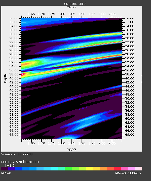
| Estimated Moho Depth: |
37.75 km |
| Estimated Crust Vp/Vs: |
1.60 |
| Assumed Crust Vp: |
6.566 km/s |
| Estimated Crust Vs: |
4.104 km/s |
| Estimated Crust Poisson's Ratio: |
0.18 |
|
| Radial Match: |
88.72988 % |
| Radial Bump: |
400 |
| Transverse Match: |
70.97172 % |
| Transverse Bump: |
400 |
| SOD ConfigId: |
4480 |
| Insert Time: |
2010-02-27 06:52:27.825 +0000 |
| GWidth: |
2.5 |
| Max Bumps: |
400 |
| Tol: |
0.001 |
|
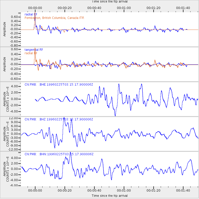
Signal To Noise
| Channel | StoN | STA | LTA |
| CN:PMB: :BHZ:19960225T03:15:17.900006Z | 3.8275871 | 1.7491686E-6 | 4.569899E-7 |
| CN:PMB: :BHN:19960225T03:15:17.900006Z | 1.453898 | 8.147041E-7 | 5.603585E-7 |
| CN:PMB: :BHE:19960225T03:15:17.900006Z | 1.8524151 | 7.979325E-7 | 4.3075252E-7 |
| Arrivals |
| Ps | 3.7 SECOND |
| PpPs | 14 SECOND |
| PsPs/PpSs | 18 SECOND |


