You are here: Home > Network List > US - United States National Seismic Network Stations List
> Station LRAL Lakeview Retreat, Alabama, USA > Earthquake Result Viewer
LRAL Lakeview Retreat, Alabama, USA - Earthquake Result Viewer
| Earthquake location: |
Near Coast Of Central Chile |
| Earthquake latitude/longitude: |
-32.6/-71.4 |
| Earthquake time(UTC): |
2012/04/17 (108) 03:50:15 GMT |
| Earthquake Depth: |
29 km |
| Earthquake Magnitude: |
6.7 MW, 6.2 MB, 6.2 MS, 6.7 MW |
| Earthquake Catalog/Contributor: |
NEIC PDE/NEIC PDE-M |
|
| Network: |
US United States National Seismic Network |
| Station: |
LRAL Lakeview Retreat, Alabama, USA |
| Lat/Lon: |
33.03 N/87.00 W |
| Elevation: |
130 m |
|
| Distance: |
67.0 deg |
| Az: |
345.76 deg |
| Baz: |
165.693 deg |
| Ray Param: |
0.0572311 |
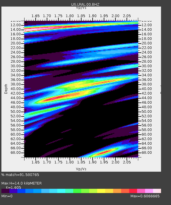
| Estimated Moho Depth: |
14.0 km |
| Estimated Crust Vp/Vs: |
1.61 |
| Assumed Crust Vp: |
6.565 km/s |
| Estimated Crust Vs: |
4.09 km/s |
| Estimated Crust Poisson's Ratio: |
0.18 |
|
| Radial Match: |
91.580765 % |
| Radial Bump: |
400 |
| Transverse Match: |
71.91754 % |
| Transverse Bump: |
400 |
| SOD ConfigId: |
558545 |
| Insert Time: |
2013-09-19 16:20:43.140 +0000 |
| GWidth: |
2.5 |
| Max Bumps: |
400 |
| Tol: |
0.001 |
|

Signal To Noise
| Channel | StoN | STA | LTA |
| US:LRAL:00:BHZ:20120417T04:00:34.448989Z | 17.080975 | 1.5086983E-6 | 8.8326246E-8 |
| US:LRAL:00:BH1:20120417T04:00:34.448989Z | 4.0735574 | 5.23535E-7 | 1.2852034E-7 |
| US:LRAL:00:BH2:20120417T04:00:34.448989Z | 1.5689955 | 1.9243588E-7 | 1.226491E-7 |
| Arrivals |
| Ps | 1.4 SECOND |
| PpPs | 5.3 SECOND |
| PsPs/PpSs | 6.7 SECOND |


