You are here: Home > Network List > US - United States National Seismic Network Stations List
> Station PKME Peaks-Kenny State Park, Maine, USA > Earthquake Result Viewer
PKME Peaks-Kenny State Park, Maine, USA - Earthquake Result Viewer
| Earthquake location: |
Near Coast Of Central Chile |
| Earthquake latitude/longitude: |
-32.6/-71.4 |
| Earthquake time(UTC): |
2012/04/17 (108) 03:50:15 GMT |
| Earthquake Depth: |
29 km |
| Earthquake Magnitude: |
6.7 MW, 6.2 MB, 6.2 MS, 6.7 MW |
| Earthquake Catalog/Contributor: |
NEIC PDE/NEIC PDE-M |
|
| Network: |
US United States National Seismic Network |
| Station: |
PKME Peaks-Kenny State Park, Maine, USA |
| Lat/Lon: |
45.26 N/69.29 W |
| Elevation: |
108 m |
|
| Distance: |
77.5 deg |
| Az: |
1.499 deg |
| Baz: |
181.792 deg |
| Ray Param: |
0.050211605 |
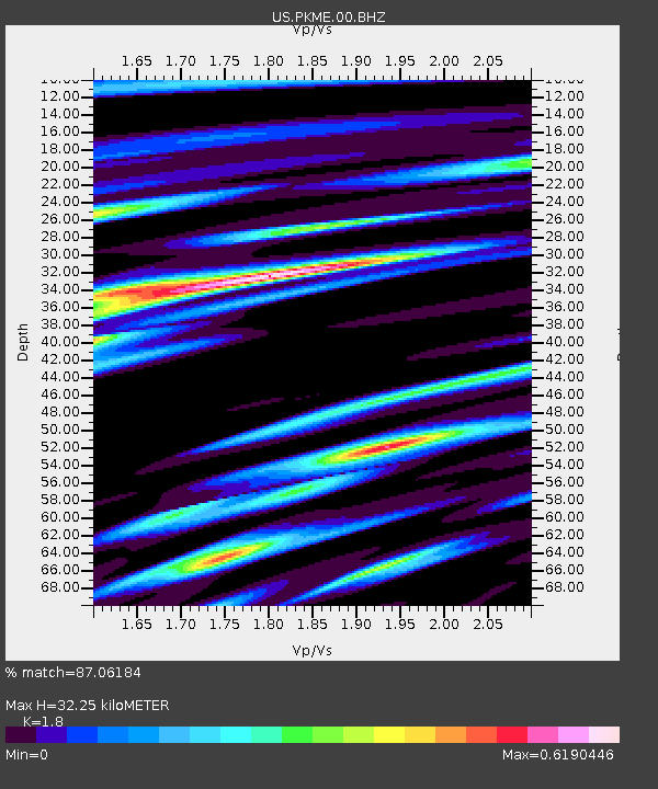
| Estimated Moho Depth: |
32.25 km |
| Estimated Crust Vp/Vs: |
1.80 |
| Assumed Crust Vp: |
6.419 km/s |
| Estimated Crust Vs: |
3.566 km/s |
| Estimated Crust Poisson's Ratio: |
0.28 |
|
| Radial Match: |
87.06184 % |
| Radial Bump: |
400 |
| Transverse Match: |
66.65223 % |
| Transverse Bump: |
400 |
| SOD ConfigId: |
558545 |
| Insert Time: |
2013-09-19 16:21:16.117 +0000 |
| GWidth: |
2.5 |
| Max Bumps: |
400 |
| Tol: |
0.001 |
|

Signal To Noise
| Channel | StoN | STA | LTA |
| US:PKME:00:BHZ:20120417T04:01:37.524978Z | 6.65349 | 1.5461128E-6 | 2.3237621E-7 |
| US:PKME:00:BH1:20120417T04:01:37.524978Z | 3.7547262 | 6.8211557E-7 | 1.8166853E-7 |
| US:PKME:00:BH2:20120417T04:01:37.524978Z | 1.466723 | 2.440278E-7 | 1.6637621E-7 |
| Arrivals |
| Ps | 4.1 SECOND |
| PpPs | 14 SECOND |
| PsPs/PpSs | 18 SECOND |


