You are here: Home > Network List > CN - Canadian National Seismograph Network Stations List
> Station PMB Pemberton, British Columbia, Canada > Earthquake Result Viewer
PMB Pemberton, British Columbia, Canada - Earthquake Result Viewer
| Earthquake location: |
Tonga Islands |
| Earthquake latitude/longitude: |
-21.8/-175.8 |
| Earthquake time(UTC): |
1998/07/19 (200) 15:58:38 GMT |
| Earthquake Depth: |
72 km |
| Earthquake Magnitude: |
5.9 MB, 6.1 UNKNOWN, 6.0 MW |
| Earthquake Catalog/Contributor: |
WHDF/NEIC |
|
| Network: |
CN Canadian National Seismograph Network |
| Station: |
PMB Pemberton, British Columbia, Canada |
| Lat/Lon: |
50.52 N/123.08 W |
| Elevation: |
400 m |
|
| Distance: |
85.7 deg |
| Az: |
30.619 deg |
| Baz: |
227.843 deg |
| Ray Param: |
0.044423763 |
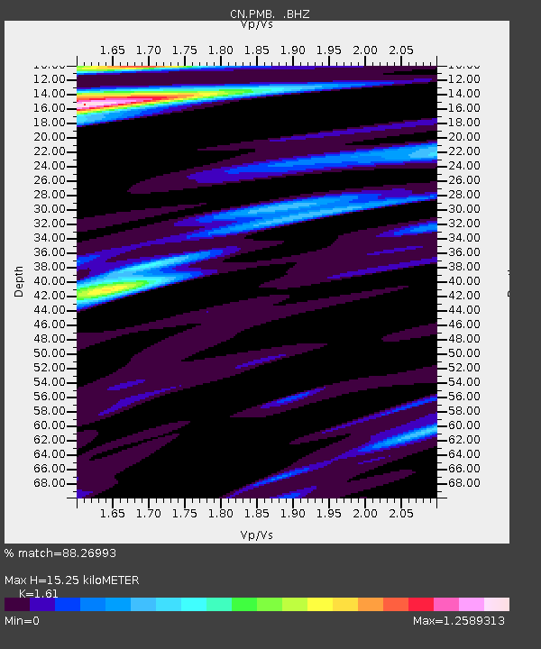
| Estimated Moho Depth: |
15.25 km |
| Estimated Crust Vp/Vs: |
1.61 |
| Assumed Crust Vp: |
6.566 km/s |
| Estimated Crust Vs: |
4.078 km/s |
| Estimated Crust Poisson's Ratio: |
0.19 |
|
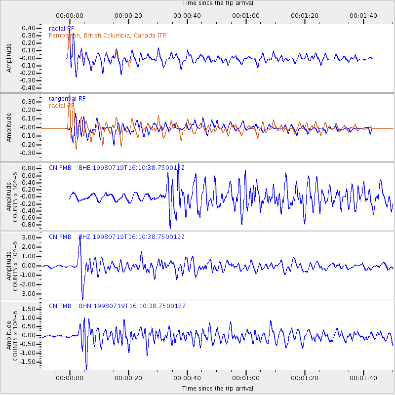
| Radial Match: |
88.26993 % |
| Radial Bump: |
400 |
| Transverse Match: |
84.715004 % |
| Transverse Bump: |
400 |
| SOD ConfigId: |
4480 |
| Insert Time: |
2010-02-27 06:52:42.930 +0000 |
| GWidth: |
2.5 |
| Max Bumps: |
400 |
| Tol: |
0.001 |
|
Signal To Noise
| Channel | StoN | STA | LTA |
| CN:PMB: :BHZ:19980719T16:10:38.750012Z | 16.446615 | 1.5123645E-6 | 9.1955975E-8 |
| CN:PMB: :BHN:19980719T16:10:38.750012Z | 4.454873 | 3.191711E-7 | 7.164539E-8 |
| CN:PMB: :BHE:19980719T16:10:38.750012Z | 3.685085 | 3.1385892E-7 | 8.517006E-8 |
| Arrivals |
| Ps | 1.5 SECOND |
| PpPs | 5.9 SECOND |
| PsPs/PpSs | 7.4 SECOND |


