You are here: Home > Network List > US - United States National Seismic Network Stations List
> Station TZTN Tazewell, Tennessee, USA > Earthquake Result Viewer
TZTN Tazewell, Tennessee, USA - Earthquake Result Viewer
| Earthquake location: |
Near Coast Of Central Chile |
| Earthquake latitude/longitude: |
-32.6/-71.4 |
| Earthquake time(UTC): |
2012/04/17 (108) 03:50:15 GMT |
| Earthquake Depth: |
29 km |
| Earthquake Magnitude: |
6.7 MW, 6.2 MB, 6.2 MS, 6.7 MW |
| Earthquake Catalog/Contributor: |
NEIC PDE/NEIC PDE-M |
|
| Network: |
US United States National Seismic Network |
| Station: |
TZTN Tazewell, Tennessee, USA |
| Lat/Lon: |
36.54 N/83.55 W |
| Elevation: |
394 m |
|
| Distance: |
69.7 deg |
| Az: |
349.563 deg |
| Baz: |
169.057 deg |
| Ray Param: |
0.05539934 |
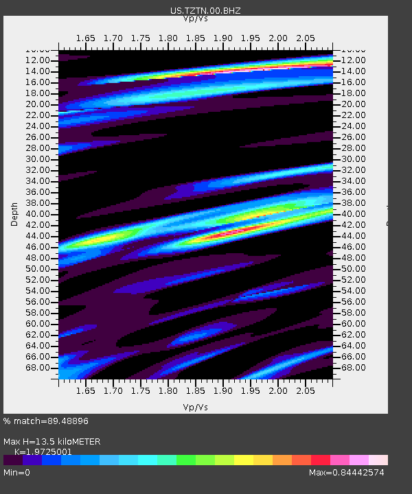
| Estimated Moho Depth: |
13.5 km |
| Estimated Crust Vp/Vs: |
1.97 |
| Assumed Crust Vp: |
6.476 km/s |
| Estimated Crust Vs: |
3.283 km/s |
| Estimated Crust Poisson's Ratio: |
0.33 |
|
| Radial Match: |
89.48896 % |
| Radial Bump: |
400 |
| Transverse Match: |
80.73811 % |
| Transverse Bump: |
400 |
| SOD ConfigId: |
558545 |
| Insert Time: |
2013-09-19 16:21:29.195 +0000 |
| GWidth: |
2.5 |
| Max Bumps: |
400 |
| Tol: |
0.001 |
|

Signal To Noise
| Channel | StoN | STA | LTA |
| US:TZTN:00:BHZ:20120417T04:00:51.899978Z | 8.10834 | 1.5443807E-6 | 1.9046817E-7 |
| US:TZTN:00:BH1:20120417T04:00:51.899978Z | 5.5684547 | 5.847144E-7 | 1.0500479E-7 |
| US:TZTN:00:BH2:20120417T04:00:51.899978Z | 1.3704429 | 1.4623168E-7 | 1.0670396E-7 |
| Arrivals |
| Ps | 2.1 SECOND |
| PpPs | 6.0 SECOND |
| PsPs/PpSs | 8.1 SECOND |


