You are here: Home > Network List > CN - Canadian National Seismograph Network Stations List
> Station PMB Pemberton, British Columbia, Canada > Earthquake Result Viewer
PMB Pemberton, British Columbia, Canada - Earthquake Result Viewer

| Earthquake location: |
Vanuatu Islands |
| Earthquake latitude/longitude: |
-13.6/166.9 |
| Earthquake time(UTC): |
1998/07/25 (206) 02:39:23 GMT |
| Earthquake Depth: |
44 km |
| Earthquake Magnitude: |
5.9 MB, 6.0 MS, 6.3 UNKNOWN, 6.2 MW |
| Earthquake Catalog/Contributor: |
WHDF/NEIC |
|
| Network: |
CN Canadian National Seismograph Network |
| Station: |
PMB Pemberton, British Columbia, Canada |
| Lat/Lon: |
50.52 N/123.08 W |
| Elevation: |
400 m |
|
| Distance: |
88.2 deg |
| Az: |
36.898 deg |
| Baz: |
246.126 deg |
| Ray Param: |
0.04270943 |
| Estimated Moho Depth: |
14.25 km |
| Estimated Crust Vp/Vs: |
1.65 |
| Assumed Crust Vp: |
6.566 km/s |
| Estimated Crust Vs: |
3.967 km/s |
| Estimated Crust Poisson's Ratio: |
0.21 |
|
| Radial Match: |
85.408424 % |
| Radial Bump: |
400 |
| Transverse Match: |
83.9637 % |
| Transverse Bump: |
400 |
| SOD ConfigId: |
4480 |
| Insert Time: |
2010-02-27 06:52:45.544 +0000 |
| GWidth: |
2.5 |
| Max Bumps: |
400 |
| Tol: |
0.001 |
|
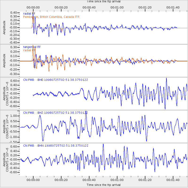
Signal To Noise
| Channel | StoN | STA | LTA |
| CN:PMB: :BHZ:19980725T02:51:38.375012Z | 7.1350994 | 4.021466E-7 | 5.636174E-8 |
| CN:PMB: :BHN:19980725T02:51:38.375012Z | 1.0251095 | 5.2493665E-8 | 5.120786E-8 |
| CN:PMB: :BHE:19980725T02:51:38.375012Z | 2.064256 | 1.1364165E-7 | 5.505211E-8 |
| Arrivals |
| Ps | 1.5 SECOND |
| PpPs | 5.6 SECOND |
| PsPs/PpSs | 7.1 SECOND |


