You are here: Home > Network List > CN - Canadian National Seismograph Network Stations List
> Station PMB Pemberton, British Columbia, Canada > Earthquake Result Viewer
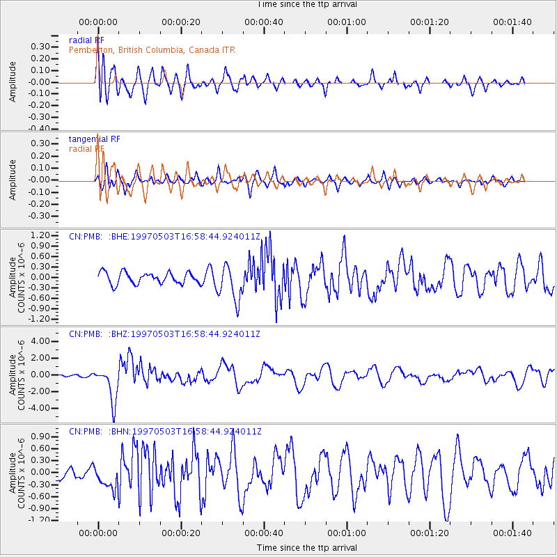
PMB Pemberton, British Columbia, Canada - Earthquake Result Viewer
*The percent match for this event was below the threshold and hence no stack was calculated.
| Earthquake location: |
Kermadec Islands Region |
| Earthquake latitude/longitude: |
-31.8/-179.4 |
| Earthquake time(UTC): |
1997/05/03 (123) 16:46:02 GMT |
| Earthquake Depth: |
108 km |
| Earthquake Magnitude: |
6.6 MB, 6.9 UNKNOWN, 6.8 ME |
| Earthquake Catalog/Contributor: |
WHDF/NEIC |
|
| Network: |
CN Canadian National Seismograph Network |
| Station: |
PMB Pemberton, British Columbia, Canada |
| Lat/Lon: |
50.52 N/123.08 W |
| Elevation: |
400 m |
|
| Distance: |
95.9 deg |
| Az: |
32.27 deg |
| Baz: |
225.415 deg |
| Ray Param: |
$rayparam |
*The percent match for this event was below the threshold and hence was not used in the summary stack. |
|
| Radial Match: |
73.47165 % |
| Radial Bump: |
400 |
| Transverse Match: |
67.060036 % |
| Transverse Bump: |
400 |
| SOD ConfigId: |
4480 |
| Insert Time: |
2010-02-27 06:52:53.703 +0000 |
| GWidth: |
2.5 |
| Max Bumps: |
400 |
| Tol: |
0.001 |
|
Signal To Noise
| Channel | StoN | STA | LTA |
| CN:PMB: :BHZ:19970503T16:58:44.924011Z | 17.511835 | 2.1644585E-6 | 1.2359975E-7 |
| CN:PMB: :BHN:19970503T16:58:44.924011Z | 1.5237101 | 3.0535946E-7 | 2.0040524E-7 |
| CN:PMB: :BHE:19970503T16:58:44.924011Z | 3.1980145 | 5.266445E-7 | 1.646786E-7 |
| Arrivals |
| Ps | |
| PpPs | |
| PsPs/PpSs | |


