You are here: Home > Network List > AU - Australian Seismological Centre Stations List
> Station PSAB3 Pilbara Seismic Array Element B3 > Earthquake Result Viewer
PSAB3 Pilbara Seismic Array Element B3 - Earthquake Result Viewer
| Earthquake location: |
Eastern New Guinea Reg., P.N.G. |
| Earthquake latitude/longitude: |
-5.5/147.1 |
| Earthquake time(UTC): |
2012/04/17 (108) 07:13:49 GMT |
| Earthquake Depth: |
198 km |
| Earthquake Magnitude: |
6.8 MW, 6.5 MB, 6.8 MW |
| Earthquake Catalog/Contributor: |
NEIC PDE/NEIC PDE-M |
|
| Network: |
AU Australian Seismological Centre |
| Station: |
PSAB3 Pilbara Seismic Array Element B3 |
| Lat/Lon: |
21.59 S/119.85 E |
| Elevation: |
327 m |
|
| Distance: |
30.9 deg |
| Az: |
236.141 deg |
| Baz: |
62.658 deg |
| Ray Param: |
0.0787138 |
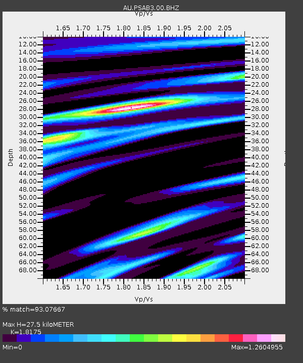
| Estimated Moho Depth: |
27.5 km |
| Estimated Crust Vp/Vs: |
1.82 |
| Assumed Crust Vp: |
6.464 km/s |
| Estimated Crust Vs: |
3.556 km/s |
| Estimated Crust Poisson's Ratio: |
0.28 |
|
| Radial Match: |
93.07667 % |
| Radial Bump: |
351 |
| Transverse Match: |
83.55975 % |
| Transverse Bump: |
400 |
| SOD ConfigId: |
558545 |
| Insert Time: |
2013-09-19 16:23:19.858 +0000 |
| GWidth: |
2.5 |
| Max Bumps: |
400 |
| Tol: |
0.001 |
|

Signal To Noise
| Channel | StoN | STA | LTA |
| AU:PSAB3:00:BHZ:20120417T07:19:16.519012Z | 13.960113 | 3.7769719E-6 | 2.7055455E-7 |
| AU:PSAB3:00:BH1:20120417T07:19:16.519012Z | 10.62198 | 1.9664938E-6 | 1.851344E-7 |
| AU:PSAB3:00:BH2:20120417T07:19:16.519012Z | 10.402955 | 1.8317252E-6 | 1.7607738E-7 |
| Arrivals |
| Ps | 3.8 SECOND |
| PpPs | 11 SECOND |
| PsPs/PpSs | 15 SECOND |


