You are here: Home > Network List > ER - Mount Erebus Volcano Observatory Seismic Network Stations List
> Station HOO Hoopers Shoulder,Mt Erebus Volcano Observatory Network, > Earthquake Result Viewer
HOO Hoopers Shoulder,Mt Erebus Volcano Observatory Network, - Earthquake Result Viewer
| Earthquake location: |
Eastern New Guinea Reg., P.N.G. |
| Earthquake latitude/longitude: |
-5.5/147.1 |
| Earthquake time(UTC): |
2012/04/17 (108) 07:13:49 GMT |
| Earthquake Depth: |
198 km |
| Earthquake Magnitude: |
6.8 MW, 6.5 MB, 6.8 MW |
| Earthquake Catalog/Contributor: |
NEIC PDE/NEIC PDE-M |
|
| Network: |
ER Mount Erebus Volcano Observatory Seismic Network |
| Station: |
HOO Hoopers Shoulder,Mt Erebus Volcano Observatory Network, |
| Lat/Lon: |
77.53 S/166.93 E |
| Elevation: |
2069 m |
|
| Distance: |
72.8 deg |
| Az: |
175.578 deg |
| Baz: |
339.312 deg |
| Ray Param: |
0.052897487 |
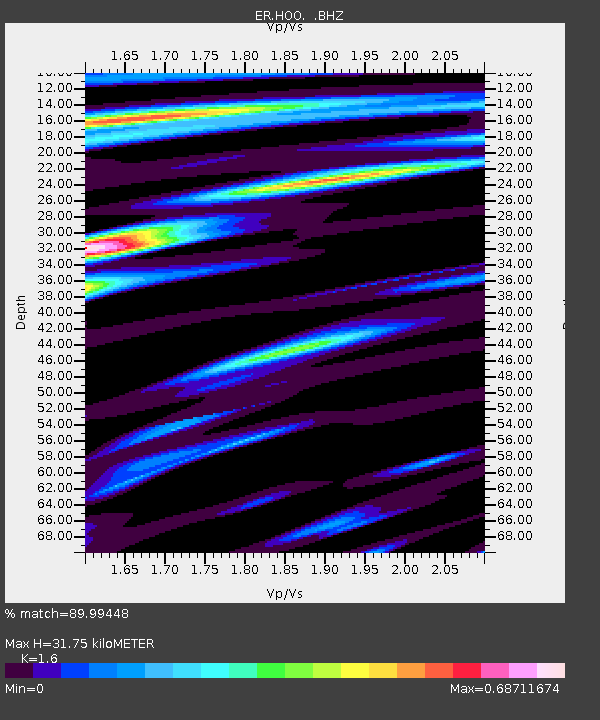
| Estimated Moho Depth: |
31.75 km |
| Estimated Crust Vp/Vs: |
1.60 |
| Assumed Crust Vp: |
6.183 km/s |
| Estimated Crust Vs: |
3.864 km/s |
| Estimated Crust Poisson's Ratio: |
0.18 |
|
| Radial Match: |
89.99448 % |
| Radial Bump: |
286 |
| Transverse Match: |
84.03092 % |
| Transverse Bump: |
400 |
| SOD ConfigId: |
558545 |
| Insert Time: |
2013-09-19 16:23:36.717 +0000 |
| GWidth: |
2.5 |
| Max Bumps: |
400 |
| Tol: |
0.001 |
|

Signal To Noise
| Channel | StoN | STA | LTA |
| ER:HOO: :BHZ:20120417T07:24:24.750Z | 24.767862 | 1.3767551E-5 | 5.558635E-7 |
| ER:HOO: :BH1:20120417T07:24:24.750Z | 6.7745833 | 3.5052196E-6 | 5.174074E-7 |
| ER:HOO: :BH2:20120417T07:24:24.750Z | 8.6671 | 5.757031E-6 | 6.6423956E-7 |
| Arrivals |
| Ps | 3.2 SECOND |
| PpPs | 13 SECOND |
| PsPs/PpSs | 16 SECOND |


