You are here: Home > Network List > II - Global Seismograph Network (GSN - IRIS/IDA) Stations List
> Station PALK Pallekele, Sri Lanka > Earthquake Result Viewer
PALK Pallekele, Sri Lanka - Earthquake Result Viewer
| Earthquake location: |
Eastern New Guinea Reg., P.N.G. |
| Earthquake latitude/longitude: |
-5.5/147.1 |
| Earthquake time(UTC): |
2012/04/17 (108) 07:13:49 GMT |
| Earthquake Depth: |
198 km |
| Earthquake Magnitude: |
6.8 MW, 6.5 MB, 6.8 MW |
| Earthquake Catalog/Contributor: |
NEIC PDE/NEIC PDE-M |
|
| Network: |
II Global Seismograph Network (GSN - IRIS/IDA) |
| Station: |
PALK Pallekele, Sri Lanka |
| Lat/Lon: |
7.27 N/80.70 E |
| Elevation: |
460 m |
|
| Distance: |
67.5 deg |
| Az: |
280.147 deg |
| Baz: |
98.963 deg |
| Ray Param: |
0.056372143 |
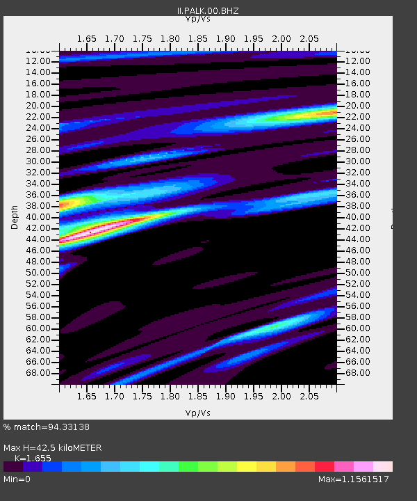
| Estimated Moho Depth: |
42.5 km |
| Estimated Crust Vp/Vs: |
1.65 |
| Assumed Crust Vp: |
6.545 km/s |
| Estimated Crust Vs: |
3.955 km/s |
| Estimated Crust Poisson's Ratio: |
0.21 |
|
| Radial Match: |
94.33138 % |
| Radial Bump: |
391 |
| Transverse Match: |
80.387024 % |
| Transverse Bump: |
400 |
| SOD ConfigId: |
558545 |
| Insert Time: |
2013-09-19 16:23:58.499 +0000 |
| GWidth: |
2.5 |
| Max Bumps: |
400 |
| Tol: |
0.001 |
|
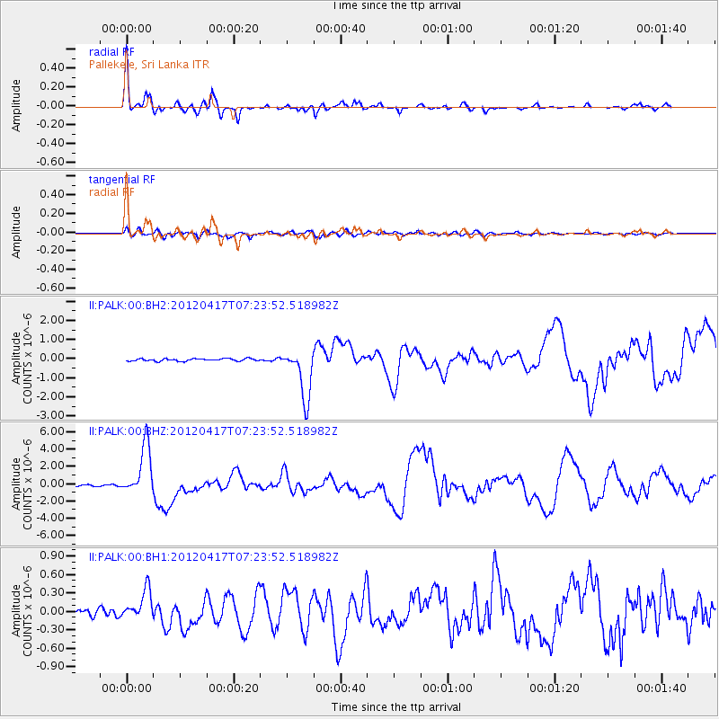
Signal To Noise
| Channel | StoN | STA | LTA |
| II:PALK:00:BHZ:20120417T07:23:52.518982Z | 34.868683 | 2.9876667E-6 | 8.568338E-8 |
| II:PALK:00:BH1:20120417T07:23:52.518982Z | 3.77973 | 2.403338E-7 | 6.358491E-8 |
| II:PALK:00:BH2:20120417T07:23:52.518982Z | 20.811054 | 1.3420811E-6 | 6.448886E-8 |
| Arrivals |
| Ps | 4.4 SECOND |
| PpPs | 17 SECOND |
| PsPs/PpSs | 21 SECOND |


