You are here: Home > Network List > IU - Global Seismograph Network (GSN - IRIS/USGS) Stations List
> Station NWAO Narrogin, Australia > Earthquake Result Viewer
NWAO Narrogin, Australia - Earthquake Result Viewer
| Earthquake location: |
Eastern New Guinea Reg., P.N.G. |
| Earthquake latitude/longitude: |
-5.5/147.1 |
| Earthquake time(UTC): |
2012/04/17 (108) 07:13:49 GMT |
| Earthquake Depth: |
198 km |
| Earthquake Magnitude: |
6.8 MW, 6.5 MB, 6.8 MW |
| Earthquake Catalog/Contributor: |
NEIC PDE/NEIC PDE-M |
|
| Network: |
IU Global Seismograph Network (GSN - IRIS/USGS) |
| Station: |
NWAO Narrogin, Australia |
| Lat/Lon: |
32.93 S/117.24 E |
| Elevation: |
380 m |
|
| Distance: |
39.0 deg |
| Az: |
221.736 deg |
| Baz: |
51.998 deg |
| Ray Param: |
0.074484766 |
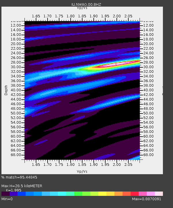
| Estimated Moho Depth: |
28.5 km |
| Estimated Crust Vp/Vs: |
2.00 |
| Assumed Crust Vp: |
6.419 km/s |
| Estimated Crust Vs: |
3.218 km/s |
| Estimated Crust Poisson's Ratio: |
0.33 |
|
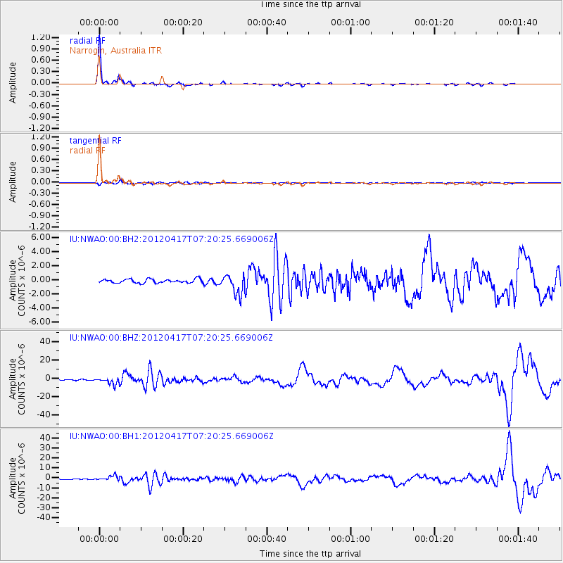
| Radial Match: |
95.44845 % |
| Radial Bump: |
173 |
| Transverse Match: |
69.803314 % |
| Transverse Bump: |
400 |
| SOD ConfigId: |
558545 |
| Insert Time: |
2013-09-19 16:24:36.220 +0000 |
| GWidth: |
2.5 |
| Max Bumps: |
400 |
| Tol: |
0.001 |
|
Signal To Noise
| Channel | StoN | STA | LTA |
| IU:NWAO:00:BHZ:20120417T07:20:25.669006Z | 9.453916 | 3.6299991E-6 | 3.8396777E-7 |
| IU:NWAO:00:BH1:20120417T07:20:25.669006Z | 9.824141 | 2.3462487E-6 | 2.3882484E-7 |
| IU:NWAO:00:BH2:20120417T07:20:25.669006Z | 5.2783766 | 1.4207998E-6 | 2.6917365E-7 |
| Arrivals |
| Ps | 4.7 SECOND |
| PpPs | 12 SECOND |
| PsPs/PpSs | 17 SECOND |


