You are here: Home > Network List > UW - Pacific Northwest Regional Seismic Network Stations List
> Station LEBA Lebam, WA, USA > Earthquake Result Viewer
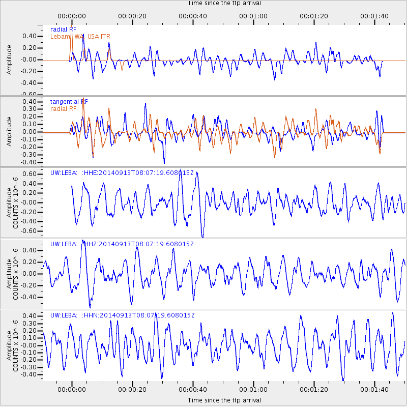
LEBA Lebam, WA, USA - Earthquake Result Viewer
*The percent match for this event was below the threshold and hence no stack was calculated.
| Earthquake location: |
Iceland |
| Earthquake latitude/longitude: |
64.7/-17.5 |
| Earthquake time(UTC): |
2014/09/13 (256) 07:58:18 GMT |
| Earthquake Depth: |
10 km |
| Earthquake Magnitude: |
5.1 MW |
| Earthquake Catalog/Contributor: |
ISC/ISC |
|
| Network: |
UW Pacific Northwest Regional Seismic Network |
| Station: |
LEBA Lebam, WA, USA |
| Lat/Lon: |
46.55 N/123.56 W |
| Elevation: |
73 m |
|
| Distance: |
55.2 deg |
| Az: |
306.083 deg |
| Baz: |
30.226 deg |
| Ray Param: |
$rayparam |
*The percent match for this event was below the threshold and hence was not used in the summary stack. |
|
| Radial Match: |
56.919556 % |
| Radial Bump: |
400 |
| Transverse Match: |
43.185436 % |
| Transverse Bump: |
400 |
| SOD ConfigId: |
3390531 |
| Insert Time: |
2019-04-14 00:42:08.608 +0000 |
| GWidth: |
2.5 |
| Max Bumps: |
400 |
| Tol: |
0.001 |
|
Signal To Noise
| Channel | StoN | STA | LTA |
| UW:LEBA: :HHZ:20140913T08:07:19.608015Z | 1.93255 | 3.223732E-7 | 1.6681236E-7 |
| UW:LEBA: :HHN:20140913T08:07:19.608015Z | 1.0961977 | 1.9323824E-7 | 1.7628045E-7 |
| UW:LEBA: :HHE:20140913T08:07:19.608015Z | 0.86216056 | 2.0209855E-7 | 2.3440941E-7 |
| Arrivals |
| Ps | |
| PpPs | |
| PsPs/PpSs | |


