You are here: Home > Network List > IU - Global Seismograph Network (GSN - IRIS/USGS) Stations List
> Station SNZO South Karori, New Zealand > Earthquake Result Viewer
SNZO South Karori, New Zealand - Earthquake Result Viewer
| Earthquake location: |
Eastern New Guinea Reg., P.N.G. |
| Earthquake latitude/longitude: |
-5.5/147.1 |
| Earthquake time(UTC): |
2012/04/17 (108) 07:13:49 GMT |
| Earthquake Depth: |
198 km |
| Earthquake Magnitude: |
6.8 MW, 6.5 MB, 6.8 MW |
| Earthquake Catalog/Contributor: |
NEIC PDE/NEIC PDE-M |
|
| Network: |
IU Global Seismograph Network (GSN - IRIS/USGS) |
| Station: |
SNZO South Karori, New Zealand |
| Lat/Lon: |
41.31 S/174.70 E |
| Elevation: |
120 m |
|
| Distance: |
43.4 deg |
| Az: |
149.468 deg |
| Baz: |
317.831 deg |
| Ray Param: |
0.071825445 |
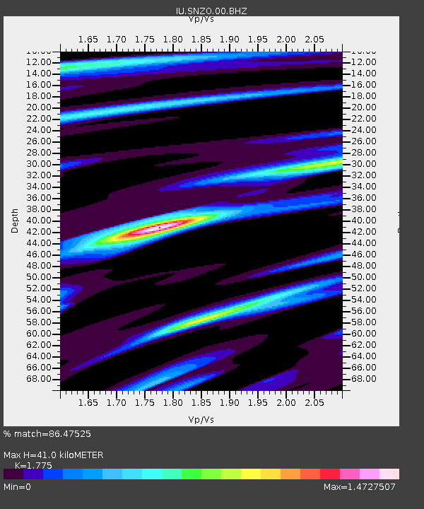
| Estimated Moho Depth: |
41.0 km |
| Estimated Crust Vp/Vs: |
1.77 |
| Assumed Crust Vp: |
6.461 km/s |
| Estimated Crust Vs: |
3.64 km/s |
| Estimated Crust Poisson's Ratio: |
0.27 |
|
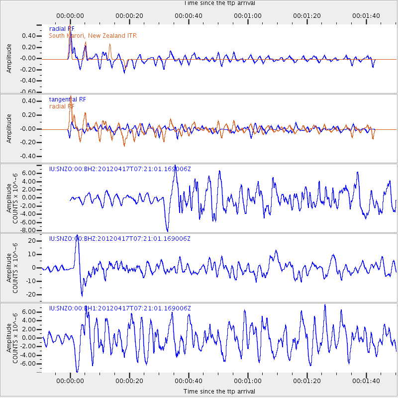
| Radial Match: |
86.47525 % |
| Radial Bump: |
400 |
| Transverse Match: |
67.755585 % |
| Transverse Bump: |
400 |
| SOD ConfigId: |
558545 |
| Insert Time: |
2013-09-19 16:24:47.477 +0000 |
| GWidth: |
2.5 |
| Max Bumps: |
400 |
| Tol: |
0.001 |
|
Signal To Noise
| Channel | StoN | STA | LTA |
| IU:SNZO:00:BHZ:20120417T07:21:01.169006Z | 16.111473 | 1.2414364E-5 | 7.7052954E-7 |
| IU:SNZO:00:BH1:20120417T07:21:01.169006Z | 3.932922 | 3.6057122E-6 | 9.168024E-7 |
| IU:SNZO:00:BH2:20120417T07:21:01.169006Z | 3.9759686 | 3.4683846E-6 | 8.7233707E-7 |
| Arrivals |
| Ps | 5.3 SECOND |
| PpPs | 16 SECOND |
| PsPs/PpSs | 22 SECOND |


