You are here: Home > Network List > US - United States National Seismic Network Stations List
> Station HAWA Hanford, Washington, USA > Earthquake Result Viewer
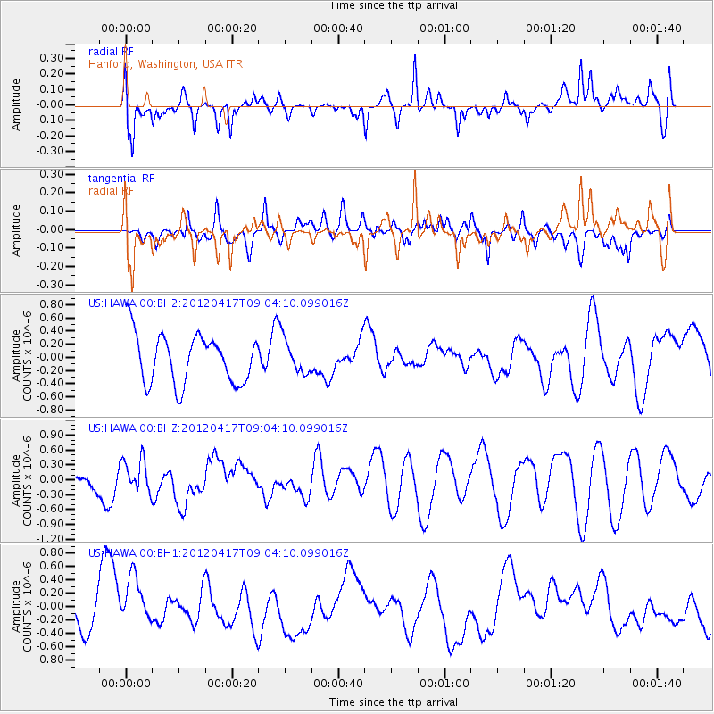
HAWA Hanford, Washington, USA - Earthquake Result Viewer
*The percent match for this event was below the threshold and hence no stack was calculated.
| Earthquake location: |
Kermadec Islands Region |
| Earthquake latitude/longitude: |
-31.9/-177.2 |
| Earthquake time(UTC): |
2012/04/17 (108) 08:51:24 GMT |
| Earthquake Depth: |
10 km |
| Earthquake Magnitude: |
5.6 MB, 5.5 MS |
| Earthquake Catalog/Contributor: |
NEIC PDE/NEIC PDE-M |
|
| Network: |
US United States National Seismic Network |
| Station: |
HAWA Hanford, Washington, USA |
| Lat/Lon: |
46.39 N/119.53 W |
| Elevation: |
364 m |
|
| Distance: |
93.7 deg |
| Az: |
35.895 deg |
| Baz: |
226.099 deg |
| Ray Param: |
$rayparam |
*The percent match for this event was below the threshold and hence was not used in the summary stack. |
|
| Radial Match: |
66.25024 % |
| Radial Bump: |
400 |
| Transverse Match: |
45.328793 % |
| Transverse Bump: |
400 |
| SOD ConfigId: |
558545 |
| Insert Time: |
2013-09-19 16:27:37.680 +0000 |
| GWidth: |
2.5 |
| Max Bumps: |
400 |
| Tol: |
0.001 |
|
Signal To Noise
| Channel | StoN | STA | LTA |
| US:HAWA:00:BHZ:20120417T09:04:10.099016Z | 0.6731003 | 3.2920673E-7 | 4.8909016E-7 |
| US:HAWA:00:BH1:20120417T09:04:10.099016Z | 1.0456539 | 4.0380937E-7 | 3.8617878E-7 |
| US:HAWA:00:BH2:20120417T09:04:10.099016Z | 0.7014315 | 2.624863E-7 | 3.7421515E-7 |
| Arrivals |
| Ps | |
| PpPs | |
| PsPs/PpSs | |


