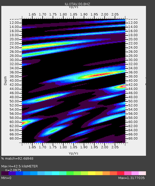
OTAV Otavalo, Ecuador - Earthquake Result Viewer
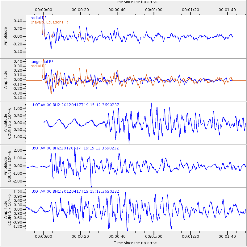
Earthquake location: East Of South Sandwich Islands
Earthquake latitude/longitude: -59.0/-16.6
Earthquake time(UTC): 2012/04/17 (108) 19:03:56 GMT
Earthquake Depth: 12 km
Earthquake Magnitude: 6.1 MB, 5.9 MS, 6.2 MW, 6.1 MW
Earthquake Catalog/Contributor: WHDF/NEIC
Network: IU Global Seismograph Network (GSN - IRIS/USGS)
Station: OTAV Otavalo, Ecuador
Lat/Lon: 0.24 N/78.45 W
Elevation: 3510 m
Distance: 76.1 deg
Az: 294.728 deg
Baz: 151.972 deg
Ray Param: 0.051234104
Estimated Moho Depth: 42.5 km
Estimated Crust Vp/Vs: 2.10
Assumed Crust Vp: 6.472 km/s
Estimated Crust Vs: 3.086 km/s
Estimated Crust Poisson's Ratio: 0.35
Radial Match: 92.46948 %
Radial Bump: 400
Transverse Match: 86.13778 %
Transverse Bump: 400
SOD ConfigId: 558545
Insert Time: 2013-09-19 16:28:50.407 +0000
GWidth: 2.5
Max Bumps: 400
Tol: 0.001

Signal To Noise

ChannelStoNSTALTA
IU:OTAV:00:BHZ:20120417T19:15:12.369023Z4.6359415.4097234E-71.1669094E-7
IU:OTAV:00:BH1:20120417T19:15:12.369023Z1.65308081.9896515E-71.2036021E-7
IU:OTAV:00:BH2:20120417T19:15:12.369023Z0.67550631.1166129E-71.6530015E-7
Arrivals
Ps7.4 SECOND
PpPs20 SECOND
PsPs/PpSs27 SECOND