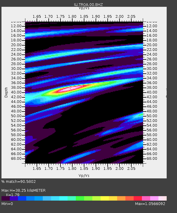
TRQA Tornquist, Argentina - Earthquake Result Viewer

Earthquake location: East Of South Sandwich Islands
Earthquake latitude/longitude: -59.0/-16.6
Earthquake time(UTC): 2012/04/17 (108) 19:03:56 GMT
Earthquake Depth: 12 km
Earthquake Magnitude: 6.1 MB, 5.9 MS, 6.2 MW, 6.1 MW
Earthquake Catalog/Contributor: WHDF/NEIC
Network: IU Global Seismograph Network (GSN - IRIS/USGS)
Station: TRQA Tornquist, Argentina
Lat/Lon: 38.06 S/61.98 W
Elevation: 540 m
Distance: 35.7 deg
Az: 285.618 deg
Baz: 140.864 deg
Ray Param: 0.07708688
Estimated Moho Depth: 38.25 km
Estimated Crust Vp/Vs: 1.79
Assumed Crust Vp: 6.472 km/s
Estimated Crust Vs: 3.616 km/s
Estimated Crust Poisson's Ratio: 0.27
Radial Match: 90.5802 %
Radial Bump: 271
Transverse Match: 61.978134 %
Transverse Bump: 374
SOD ConfigId: 558545
Insert Time: 2013-09-19 16:29:13.145 +0000
GWidth: 2.5
Max Bumps: 400
Tol: 0.001

Signal To Noise

ChannelStoNSTALTA
IU:TRQA:00:BHZ:20120417T19:10:23.618993Z11.7128474.7127087E-64.0235383E-7
IU:TRQA:00:BH1:20120417T19:10:23.618993Z8.5540242.308989E-62.6993015E-7
IU:TRQA:00:BH2:20120417T19:10:23.618993Z2.51297021.0702638E-64.2589593E-7
Arrivals
Ps5.0 SECOND
PpPs15 SECOND
PsPs/PpSs20 SECOND