You are here: Home > Network List > IU - Global Seismograph Network (GSN - IRIS/USGS) Stations List
> Station JOHN Johnston Island, USA > Earthquake Result Viewer
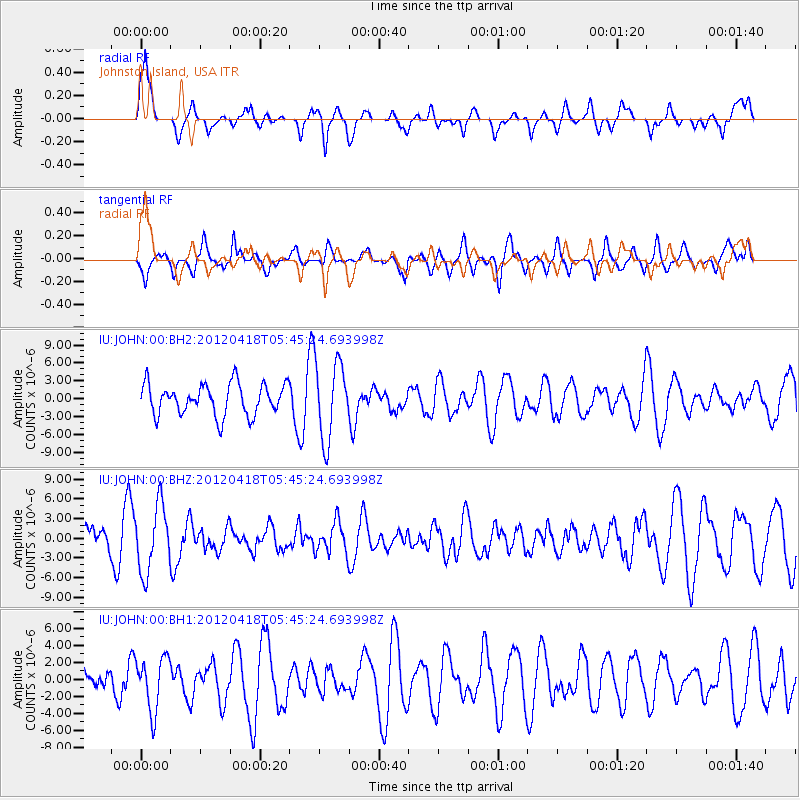
JOHN Johnston Island, USA - Earthquake Result Viewer
*The percent match for this event was below the threshold and hence no stack was calculated.
| Earthquake location: |
Bonin Islands, Japan Region |
| Earthquake latitude/longitude: |
28.7/138.8 |
| Earthquake time(UTC): |
2012/04/18 (109) 05:37:55 GMT |
| Earthquake Depth: |
494 km |
| Earthquake Magnitude: |
5.5 MW |
| Earthquake Catalog/Contributor: |
NEIC PDE/NEIC PDE-M |
|
| Network: |
IU Global Seismograph Network (GSN - IRIS/USGS) |
| Station: |
JOHN Johnston Island, USA |
| Lat/Lon: |
16.73 N/169.53 W |
| Elevation: |
2.0 m |
|
| Distance: |
48.8 deg |
| Az: |
92.454 deg |
| Baz: |
293.639 deg |
| Ray Param: |
$rayparam |
*The percent match for this event was below the threshold and hence was not used in the summary stack. |
|
| Radial Match: |
50.033096 % |
| Radial Bump: |
400 |
| Transverse Match: |
43.272366 % |
| Transverse Bump: |
400 |
| SOD ConfigId: |
558545 |
| Insert Time: |
2013-09-19 16:31:28.988 +0000 |
| GWidth: |
2.5 |
| Max Bumps: |
400 |
| Tol: |
0.001 |
|
Signal To Noise
| Channel | StoN | STA | LTA |
| IU:JOHN:00:BHZ:20120418T05:45:24.693998Z | 2.629398 | 5.0532713E-6 | 1.9218357E-6 |
| IU:JOHN:00:BH1:20120418T05:45:24.693998Z | 2.080903 | 3.1434192E-6 | 1.5106034E-6 |
| IU:JOHN:00:BH2:20120418T05:45:24.693998Z | 2.5258367 | 6.5713207E-6 | 2.6016412E-6 |
| Arrivals |
| Ps | |
| PpPs | |
| PsPs/PpSs | |


