You are here: Home > Network List > IU - Global Seismograph Network (GSN - IRIS/USGS) Stations List
> Station MAKZ Makanchi, Kazakhstan > Earthquake Result Viewer
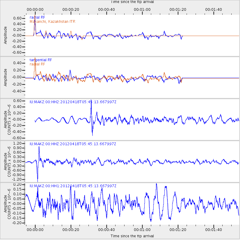
MAKZ Makanchi, Kazakhstan - Earthquake Result Viewer
*The percent match for this event was below the threshold and hence no stack was calculated.
| Earthquake location: |
Bonin Islands, Japan Region |
| Earthquake latitude/longitude: |
28.7/138.8 |
| Earthquake time(UTC): |
2012/04/18 (109) 05:37:55 GMT |
| Earthquake Depth: |
494 km |
| Earthquake Magnitude: |
5.5 MW |
| Earthquake Catalog/Contributor: |
NEIC PDE/NEIC PDE-M |
|
| Network: |
IU Global Seismograph Network (GSN - IRIS/USGS) |
| Station: |
MAKZ Makanchi, Kazakhstan |
| Lat/Lon: |
46.81 N/81.98 E |
| Elevation: |
600 m |
|
| Distance: |
47.3 deg |
| Az: |
308.605 deg |
| Baz: |
91.686 deg |
| Ray Param: |
$rayparam |
*The percent match for this event was below the threshold and hence was not used in the summary stack. |
|
| Radial Match: |
61.503708 % |
| Radial Bump: |
400 |
| Transverse Match: |
46.04237 % |
| Transverse Bump: |
400 |
| SOD ConfigId: |
558545 |
| Insert Time: |
2013-09-19 16:31:36.877 +0000 |
| GWidth: |
2.5 |
| Max Bumps: |
400 |
| Tol: |
0.001 |
|
Signal To Noise
| Channel | StoN | STA | LTA |
| IU:MAKZ:00:HHZ:20120418T05:45:13.667997Z | 5.5806665 | 4.0652648E-7 | 7.284551E-8 |
| IU:MAKZ:00:HH1:20120418T05:45:13.667997Z | 0.9453508 | 6.188004E-8 | 6.5457215E-8 |
| IU:MAKZ:00:HH2:20120418T05:45:13.667997Z | 3.5097184 | 2.0394337E-7 | 5.810819E-8 |
| Arrivals |
| Ps | |
| PpPs | |
| PsPs/PpSs | |


