You are here: Home > Network List > CN - Canadian National Seismograph Network Stations List
> Station PMB Pemberton, British Columbia, Canada > Earthquake Result Viewer
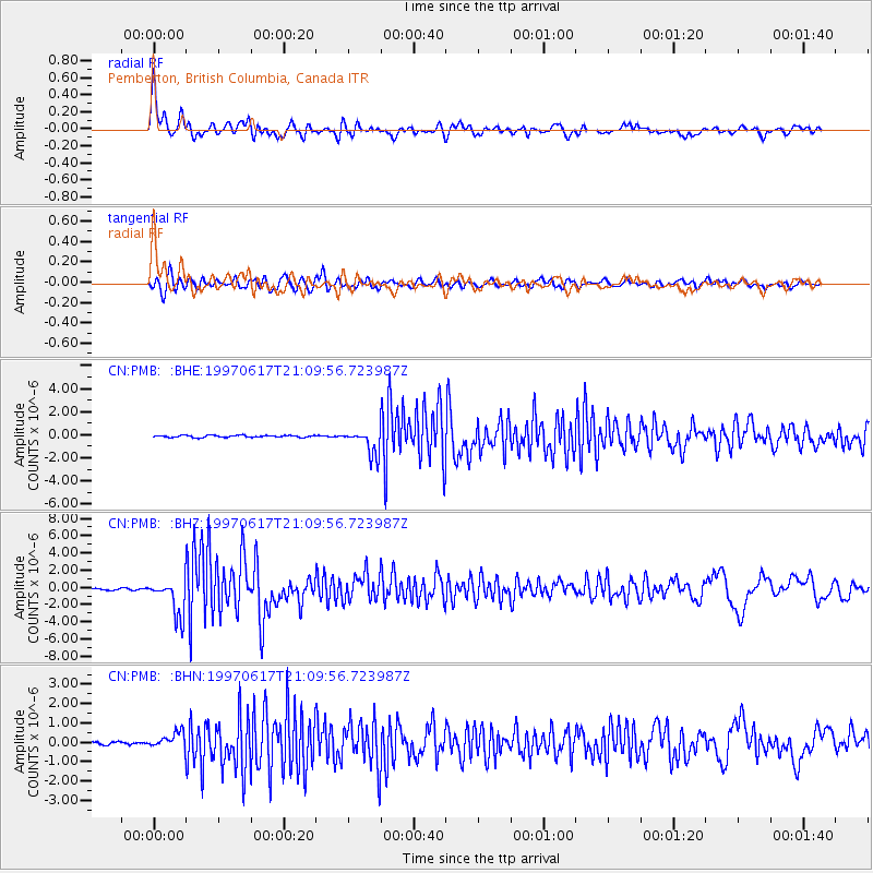
PMB Pemberton, British Columbia, Canada - Earthquake Result Viewer
*The percent match for this event was below the threshold and hence no stack was calculated.
| Earthquake location: |
Andreanof Islands, Aleutian Is. |
| Earthquake latitude/longitude: |
51.3/-179.3 |
| Earthquake time(UTC): |
1997/06/17 (168) 21:03:40 GMT |
| Earthquake Depth: |
33 km |
| Earthquake Magnitude: |
6.4 MB, 6.3 MS, 6.4 UNKNOWN, 6.6 ML |
| Earthquake Catalog/Contributor: |
WHDF/NEIC |
|
| Network: |
CN Canadian National Seismograph Network |
| Station: |
PMB Pemberton, British Columbia, Canada |
| Lat/Lon: |
50.52 N/123.08 W |
| Elevation: |
400 m |
|
| Distance: |
34.7 deg |
| Az: |
68.739 deg |
| Baz: |
293.713 deg |
| Ray Param: |
$rayparam |
*The percent match for this event was below the threshold and hence was not used in the summary stack. |
|
| Radial Match: |
77.69567 % |
| Radial Bump: |
400 |
| Transverse Match: |
72.27154 % |
| Transverse Bump: |
400 |
| SOD ConfigId: |
4480 |
| Insert Time: |
2010-02-27 06:53:20.378 +0000 |
| GWidth: |
2.5 |
| Max Bumps: |
400 |
| Tol: |
0.001 |
|
Signal To Noise
| Channel | StoN | STA | LTA |
| CN:PMB: :BHZ:19970617T21:09:56.723987Z | 20.544077 | 2.104934E-6 | 1.0245942E-7 |
| CN:PMB: :BHN:19970617T21:09:56.723987Z | 4.1792216 | 4.060528E-7 | 9.715991E-8 |
| CN:PMB: :BHE:19970617T21:09:56.723987Z | 12.11454 | 1.0941488E-6 | 9.0316995E-8 |
| Arrivals |
| Ps | |
| PpPs | |
| PsPs/PpSs | |


