You are here: Home > Network List > IU - Global Seismograph Network (GSN - IRIS/USGS) Stations List
> Station PMG Port Moresby, New Guinea > Earthquake Result Viewer
PMG Port Moresby, New Guinea - Earthquake Result Viewer
*The percent match for this event was below the threshold and hence no stack was calculated.
| Earthquake location: |
Off W Coast Of Northern Sumatra |
| Earthquake latitude/longitude: |
3.3/93.9 |
| Earthquake time(UTC): |
2012/04/20 (111) 22:19:46 GMT |
| Earthquake Depth: |
25 km |
| Earthquake Magnitude: |
5.8 MW, 5.7 MS, 5.7 MW |
| Earthquake Catalog/Contributor: |
NEIC PDE/NEIC PDE-M |
|
| Network: |
IU Global Seismograph Network (GSN - IRIS/USGS) |
| Station: |
PMG Port Moresby, New Guinea |
| Lat/Lon: |
9.40 S/147.16 E |
| Elevation: |
90 m |
|
| Distance: |
54.6 deg |
| Az: |
103.869 deg |
| Baz: |
280.786 deg |
| Ray Param: |
$rayparam |
*The percent match for this event was below the threshold and hence was not used in the summary stack. |
|
| Radial Match: |
74.442444 % |
| Radial Bump: |
400 |
| Transverse Match: |
59.292515 % |
| Transverse Bump: |
400 |
| SOD ConfigId: |
558545 |
| Insert Time: |
2013-09-19 16:37:02.007 +0000 |
| GWidth: |
2.5 |
| Max Bumps: |
400 |
| Tol: |
0.001 |
|
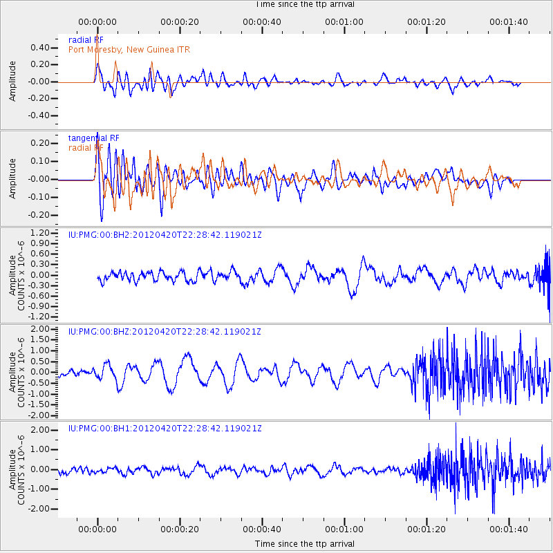
Signal To Noise
| Channel | StoN | STA | LTA |
| IU:PMG:00:BHZ:20120420T22:28:42.119021Z | 2.7737901 | 3.3031168E-7 | 1.19083154E-7 |
| IU:PMG:00:BH1:20120420T22:28:42.119021Z | 0.8930384 | 1.0732301E-7 | 1.2017738E-7 |
| IU:PMG:00:BH2:20120420T22:28:42.119021Z | 1.0377773 | 1.2791746E-7 | 1.2326099E-7 |
| Arrivals |
| Ps | |
| PpPs | |
| PsPs/PpSs | |


