You are here: Home > Network List > II - Global Seismograph Network (GSN - IRIS/IDA) Stations List
> Station WRAB Tennant Creek, NT, Australia > Earthquake Result Viewer
WRAB Tennant Creek, NT, Australia - Earthquake Result Viewer
*The percent match for this event was below the threshold and hence no stack was calculated.
| Earthquake location: |
Off W Coast Of Northern Sumatra |
| Earthquake latitude/longitude: |
2.2/93.4 |
| Earthquake time(UTC): |
2012/04/20 (111) 23:14:31 GMT |
| Earthquake Depth: |
28 km |
| Earthquake Magnitude: |
5.9 MW, 5.5 MS, 5.8 MW, 5.9 MB |
| Earthquake Catalog/Contributor: |
NEIC PDE/NEIC PDE-M |
|
| Network: |
II Global Seismograph Network (GSN - IRIS/IDA) |
| Station: |
WRAB Tennant Creek, NT, Australia |
| Lat/Lon: |
19.93 S/134.36 E |
| Elevation: |
366 m |
|
| Distance: |
45.8 deg |
| Az: |
120.614 deg |
| Baz: |
293.92 deg |
| Ray Param: |
$rayparam |
*The percent match for this event was below the threshold and hence was not used in the summary stack. |
|
| Radial Match: |
69.46901 % |
| Radial Bump: |
400 |
| Transverse Match: |
87.6796 % |
| Transverse Bump: |
342 |
| SOD ConfigId: |
558545 |
| Insert Time: |
2013-09-19 16:39:32.237 +0000 |
| GWidth: |
2.5 |
| Max Bumps: |
400 |
| Tol: |
0.001 |
|
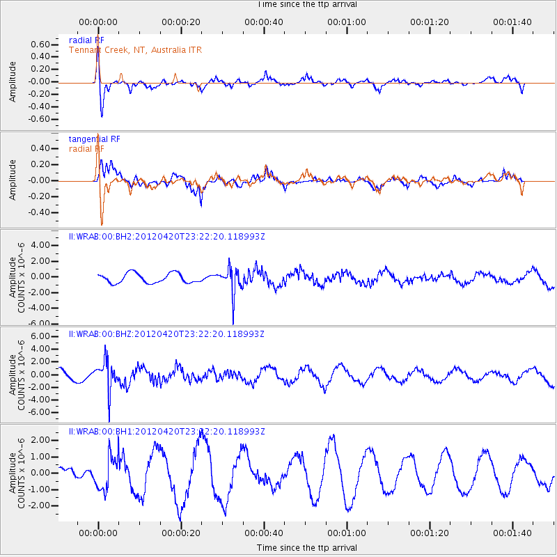
Signal To Noise
| Channel | StoN | STA | LTA |
| II:WRAB:00:BHZ:20120420T23:22:20.118993Z | 1.9781355 | 2.30412E-6 | 1.1647938E-6 |
| II:WRAB:00:BH1:20120420T23:22:20.118993Z | 1.6621174 | 1.0863458E-6 | 6.5359154E-7 |
| II:WRAB:00:BH2:20120420T23:22:20.118993Z | 2.7277474 | 1.6607273E-6 | 6.088274E-7 |
| Arrivals |
| Ps | |
| PpPs | |
| PsPs/PpSs | |


