You are here: Home > Network List > IU - Global Seismograph Network (GSN - IRIS/USGS) Stations List
> Station HNR Honiara, Solomon Islands > Earthquake Result Viewer
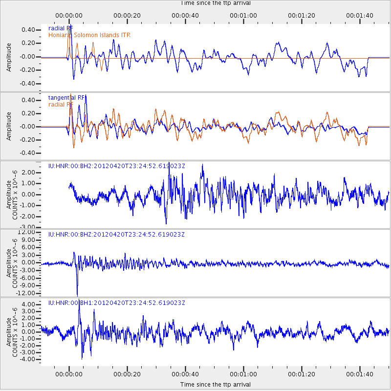
HNR Honiara, Solomon Islands - Earthquake Result Viewer
*The percent match for this event was below the threshold and hence no stack was calculated.
| Earthquake location: |
Off W Coast Of Northern Sumatra |
| Earthquake latitude/longitude: |
2.2/93.4 |
| Earthquake time(UTC): |
2012/04/20 (111) 23:14:31 GMT |
| Earthquake Depth: |
28 km |
| Earthquake Magnitude: |
5.9 MW, 5.5 MS, 5.8 MW, 5.9 MB |
| Earthquake Catalog/Contributor: |
NEIC PDE/NEIC PDE-M |
|
| Network: |
IU Global Seismograph Network (GSN - IRIS/USGS) |
| Station: |
HNR Honiara, Solomon Islands |
| Lat/Lon: |
9.44 S/159.95 E |
| Elevation: |
100 m |
|
| Distance: |
67.3 deg |
| Az: |
101.09 deg |
| Baz: |
276.322 deg |
| Ray Param: |
$rayparam |
*The percent match for this event was below the threshold and hence was not used in the summary stack. |
|
| Radial Match: |
50.084114 % |
| Radial Bump: |
400 |
| Transverse Match: |
68.26916 % |
| Transverse Bump: |
400 |
| SOD ConfigId: |
558545 |
| Insert Time: |
2013-09-19 16:39:42.867 +0000 |
| GWidth: |
2.5 |
| Max Bumps: |
400 |
| Tol: |
0.001 |
|
Signal To Noise
| Channel | StoN | STA | LTA |
| IU:HNR:00:BHZ:20120420T23:24:52.619023Z | 9.869313 | 3.1813297E-6 | 3.2234558E-7 |
| IU:HNR:00:BH1:20120420T23:24:52.619023Z | 4.071943 | 1.565958E-6 | 3.845727E-7 |
| IU:HNR:00:BH2:20120420T23:24:52.619023Z | 2.2630243 | 1.1161536E-6 | 4.932133E-7 |
| Arrivals |
| Ps | |
| PpPs | |
| PsPs/PpSs | |


