You are here: Home > Network List > IU - Global Seismograph Network (GSN - IRIS/USGS) Stations List
> Station MAJO Matsushiro, Japan > Earthquake Result Viewer
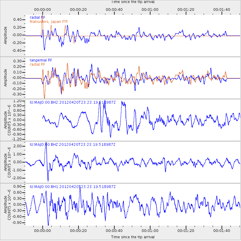
MAJO Matsushiro, Japan - Earthquake Result Viewer
*The percent match for this event was below the threshold and hence no stack was calculated.
| Earthquake location: |
Off W Coast Of Northern Sumatra |
| Earthquake latitude/longitude: |
2.2/93.4 |
| Earthquake time(UTC): |
2012/04/20 (111) 23:14:31 GMT |
| Earthquake Depth: |
28 km |
| Earthquake Magnitude: |
5.9 MW, 5.5 MS, 5.8 MW, 5.9 MB |
| Earthquake Catalog/Contributor: |
NEIC PDE/NEIC PDE-M |
|
| Network: |
IU Global Seismograph Network (GSN - IRIS/USGS) |
| Station: |
MAJO Matsushiro, Japan |
| Lat/Lon: |
36.55 N/138.20 E |
| Elevation: |
405 m |
|
| Distance: |
53.6 deg |
| Az: |
44.837 deg |
| Baz: |
241.041 deg |
| Ray Param: |
$rayparam |
*The percent match for this event was below the threshold and hence was not used in the summary stack. |
|
| Radial Match: |
55.10726 % |
| Radial Bump: |
400 |
| Transverse Match: |
71.61966 % |
| Transverse Bump: |
400 |
| SOD ConfigId: |
558545 |
| Insert Time: |
2013-09-19 16:39:52.651 +0000 |
| GWidth: |
2.5 |
| Max Bumps: |
400 |
| Tol: |
0.001 |
|
Signal To Noise
| Channel | StoN | STA | LTA |
| IU:MAJO:00:BHZ:20120420T23:23:19.518987Z | 5.2637515 | 1.1521279E-6 | 2.188796E-7 |
| IU:MAJO:00:BH1:20120420T23:23:19.518987Z | 2.541677 | 5.053662E-7 | 1.9883178E-7 |
| IU:MAJO:00:BH2:20120420T23:23:19.518987Z | 2.208457 | 6.3190134E-7 | 2.8612797E-7 |
| Arrivals |
| Ps | |
| PpPs | |
| PsPs/PpSs | |


