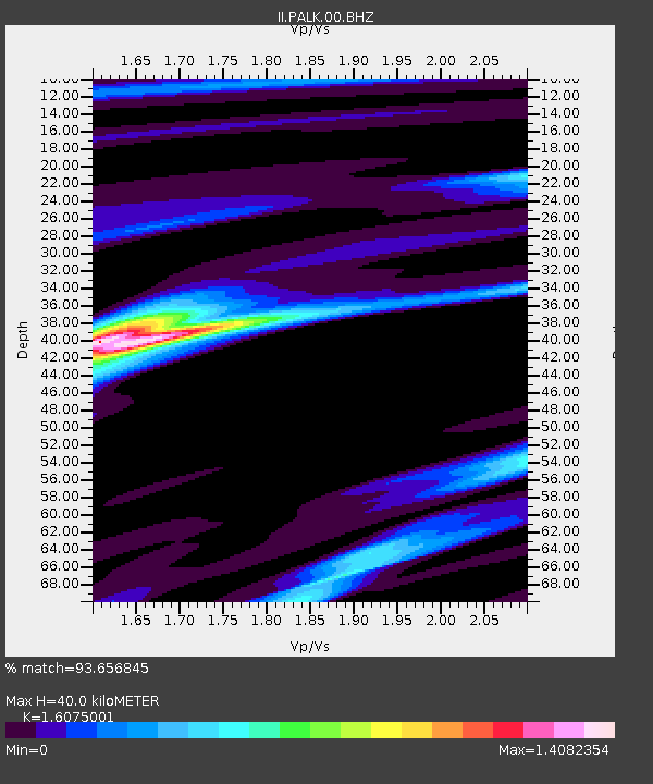
PALK Pallekele, Sri Lanka - Earthquake Result Viewer
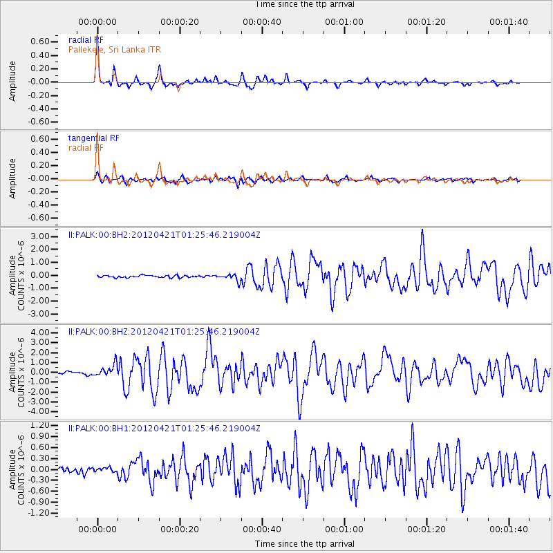
Earthquake location: Irian Jaya Region, Indonesia
Earthquake latitude/longitude: -1.6/134.3
Earthquake time(UTC): 2012/04/21 (112) 01:16:52 GMT
Earthquake Depth: 16 km
Earthquake Magnitude: 6.3 MB, 6.6 MS, 6.7 MW, 6.6 MW
Earthquake Catalog/Contributor: WHDF/NEIC
Network: II Global Seismograph Network (GSN - IRIS/IDA)
Station: PALK Pallekele, Sri Lanka
Lat/Lon: 7.27 N/80.70 E
Elevation: 460 m
Distance: 54.2 deg
Az: 280.102 deg
Baz: 97.259 deg
Ray Param: 0.06559843
Estimated Moho Depth: 40.0 km
Estimated Crust Vp/Vs: 1.61
Assumed Crust Vp: 6.545 km/s
Estimated Crust Vs: 4.072 km/s
Estimated Crust Poisson's Ratio: 0.18
Radial Match: 93.656845 %
Radial Bump: 288
Transverse Match: 72.883934 %
Transverse Bump: 400
SOD ConfigId: 558545
Insert Time: 2013-09-19 16:41:40.585 +0000
GWidth: 2.5
Max Bumps: 400
Tol: 0.001

Signal To Noise

ChannelStoNSTALTA
II:PALK:00:BHZ:20120421T01:25:46.219004Z4.83068946.257696E-71.2954044E-7
II:PALK:00:BH1:20120421T01:25:46.219004Z0.72003035.7344373E-87.964161E-8
II:PALK:00:BH2:20120421T01:25:46.219004Z3.4445942.7338092E-77.9365215E-8
Arrivals
Ps3.9 SECOND
PpPs15 SECOND
PsPs/PpSs19 SECOND